Find • port adelaide • Results 9,841 to 9,870 of 9,998


Captains of River Steamers
Group portrait of Captains George Grundy, Edward Creamer, and F. H. C. Kruse, Masters of River Murray paddle steamers. Edward Creamer or Creemer, later standardised as Cremer, first came to Australia as a sailor on a ship carrying convicts to Tasmania in the 1820s. He worked on a number of whaling ships before joining a land-based crew at Encounter Bay by 1848. He lived at Goolwa, where he married Mary Driscoll in 1850 and had a large family. He was appointed as the first signalman at the Murray Mouth in 1857, but soon returned to working as a pilot, fisherman and captain of the schooner Water Lily, carrying cargo from ports around the lakes to Goolwa. Captain Edward Cremer was appointed the first signalman when the railway was established between Adelaide and Goolwa. He was found dead in his boat after suffering a heart attack while carrying a load of salt. He was 75 years old when he died in 1892 and had been a colonist for 50 years. Captain FHC Kruse was born 25th May, 1823 in Germany and went to sea at 14 years of age. He arrived in Adelaide in 1854, settled in Milang and purchased boats to begin trading on the lakes and Cooroong. Although retired at 80 he remained active in the Milang Regattas.

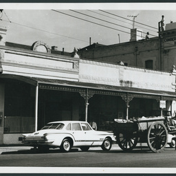
Waymouth Street
Waymouth Street, south side, 22nd March 1963, left side of shops is 21 yards west of Ranelagh Street and frontage of the block of shops is 18 yards. The corner shop and greengrocers is owned by M Bolkus. Mr Bolkus arrived in South Australia with his wife and five year old son in 1922. After a stint in Port Pirie, he moved to Adelaide in the 1930s and started his greengrocery business next to the Cumberland Arms Hotel in Waymouth Street. A young Nick Bolkus,Labour politician, born in 1950, grew up in the south west of Adelaide in a multi cultural setting.

Ken Chinner and Darrel Hodge
PORTRAIT: Ken Chinner (left) and Darrel Hodge, ski instructors with the Mercury Ski School at Snowdens Beach on the Port River.

Telegraph Station, Alice Springs
Telegraph station, Alice Springs. The Telegraph Station buildings at Alice Springs were constructed in the 1870's. The site was one of the repeater stations for the Overland Telegraph Line that ran between Adelaide and Port Darwin. It was one of twelve stations along the Overland Telegraph Line used to relay messages between Darwin and Adelaide.

Telegraph Station, Alice Springs
Telegraph station, Alice Springs, constructed in the 1870s. To compare this view with one taken from a similar perspective in the 1890s, see B 8349. The site was one of the repeater stations for the Overland Telegraph Line that ran between Adelaide and Port Darwin. It was one of twelve stations along the Overland Telegraph Line used to relay messages between Darwin and Adelaide.

Eyre Peninsula Football Touring Team
Two photographs of the Eyre Peninsula Football team in 1936, taken in Adelaide, one with team in street clothes, the other in football gear. Down each side of the frames are the signatures of the players. Across the top is the inscription: 'Presented to A.E. "Ginty" Bryant "Head Trainer" from the Eyres [sic] Peninsula touring side 1936'. In the first photograph Ginty Bryant is seated at the right hand end of the second row; in the second he is seated in front row, right hand end.

First Troop of the Goolwa Volunteer Rifles in uniform
Five men wearing the uniform of the Goolwa First Troop Volunteer Rifles, with Captain (afterwards Lieut. Colonel) Higgins, in command, far left with sword, and the others holding guns. Higgins served with the Rifle Volunteers until the Goolwa Volunteer Cavalry was formed in 1864 (Information supplied by a researcher). The second man from the left is J.W. (John Huxtable Wesley Peryman). He was the manager of the Bank of Adelaide branch at Goolwa from March 1866 until it closed in July 1867. It closed due to competition from other banks and the railway taking away river trade. His rank at that time was Lieutenant (granted 2 July 1866). He left banking and went on to farming, becoming Captain of the Red Hill Rifles, and eventually going to the reserve Volunteer Force. He went to live at Mount Magnet, Western Australian in 1892 as a miner, prospector, hotel and brewery owner. A photograph of him with other miners is published in the book 'Drawn to Mount Magnet' by Karen Morrissey and Lorna Day (information supplied by a researcher). Queen Victoria gave assent to the Volunteer act of 1865-66 (Act no. 18) on 16th March, 1866. Months prior to this the Volunteer force was in limbo. Volunteers retained their rank but the various troops were basically disbanded. Under the new regulations the government would supply uniforms and pay the troopers for each drill they attended. The Goolwa Cavalry (formerly known as the Port Elliot/Goolwa Cavalry was thus disbanded and reformed in July 1866, It was then known as the No. 1 Cavalry Troop (Encounter Bay) or commonly called the First Goolwa Cavalry. The New troop did not receive all their uniform immediately and it was not until November 1866 that they paraded in their new uniforms for the first time information supplied by a researcher). The photograph appears with names of all the men in The Observer (Adelaide, SA : 1905 - 1931),edition January 29 1910, p. 29.

Thirteen N.C.O.s from A Company, 32nd Battalion
A group of thirteen N.C.O.s from A Company, 32nd Battalion standing outside a building on steps covered in snow; Back row, left to right: Sgt. H.E. Gunders, Brisbane, Qld.; Sgt. S. Gild, Glenelg, S.A.; Sgt. G.L. Carter, Port Pirie, S.A.; Sgt. R.E. Hyman, Adelaide. Centre row, left to right: Sgt. H.J. Reynolds, Unley Park, S.A.; Sgt. H.S. Turner, Prospect, S.A.; Sgt. H.M. Gordon, Mount Gambier, S.A.; Sgt. H.L. Berry, Norwood, S.A. Front row, left to right: Sgt. F.S. Kidd, Norwood; Sgt. E.S. Mason, Forest Range, S.A.; Company Quarter Master Sgt. L.G. Moody, Blackwood, S.A.; Sgt. A. Errington, Adelaide; Company Sgt.Mjr. F.C. Stolz, Clarence Park, S.A.-

Selection of views from Album of Jean Litchfield
Selection of 9 images from the photograph album possibly of Jean Rainsbury Litchfield. See 'Contents' for details.

University Training College Students
Photograph of University Training College Students, 1900. Back row (from left): J.T. Barnes, R.G. Benny, E. Owen, R.O. Nadebaum, H.C. Bromley, E.A. Kayser, S. Owen, I.L. Ralph, A. Slane, H.K. Neate, E.E. Simpson, E. Coles, I.M. Sanders, L.H. Jefferies, A.M. Huppatz. Middle row: K. Robertson, F.I.D. Turner, H.K. Hales, M.E. Monk, E. Symmons, A.R. Hills, M.M. Maughan, H.H. Rofe, A.E.T. Durie, E.M.M. Hooper, H. Thomson, B. Buckley, C.C.T. Jeffers. Front row: V. Greenland, E.R. Smyth, C.S. Menmuir, M.A.L. O'Grady, A.R. Hay, S.E. Davey, D.M. Smith.

Photographs of river shipping and places
Photographs from Harry Godson's collection, some which had been assigned his catalogue numbers but were not included in earlier digitised series 1-4. A few have been donated since his death, to be added to his collection. Included are transparencies of aerial views of 1974 flood along River Murray, photographer unknown (Godson ref: 'Index 59'). Images 366-400 are the first in sequence, followed by images 322-352.

Papers relating to the Gray family
Photographs of the Gray family home 'Frog Moor', Reedbeds, and Gray family members, together with a covering letter from Robert Gray to Captain S.A. White. Details of the photographs are listed under items.

Bonnin family photographs
Photographs of several generations of the Bonnin family. They include babies, children and adults, and several weddings. See 'contents' for details of items.

License and photographs
Records comprising licence for navigators, engineers or ground engineers issued to Leslie Jack Lucas by the Department of Defence along with photographs of aircraft using Harry Butler's airfields at Northfield and Albert Park. Pilots photographed include Ross and Keith Smith and Frank Hurley.

War service photographs
A collection of photos relating to Thomas Chappell's time serving in the Middle East. Each image has a brief caption: many show military activities - vehicles such as trucks, tanks and horse-drawn carriages; prisoners of war; guns; captured planes; donkeys, mules and camels used for transportation; servicemen and army camps. There are also quite a few of the people, scenery and buildings in the Middle East. See items for details of individual images.

Australasian Association for the Advancement of Science
Crew of the Governor Musgrave and some of a party of scientists returning from Kirton Point to the Governor Musgrave, 16 January 1907. Seventeen scientists from South Australia, New South Wales and Victoria participated in the research trip to Kangaroo Island and Port Lincoln following the Australasian Association for the Advancement of Science congress in Adelaide.

Frank Turner Sellick
Half-plate glass negative portrait of an Australian soldier in World War One uniform, including slouch hat, standing with his hands behind his back. Written on original paper envelope: 'Mr[?] Sellick. Football Club. Copy. 3329'. The soldier may be a 'Mr Sellick' or was possibly a member of Sellick Football Club. The soldier pictured is the same as photograph as B 74897 which has 'Stuart [Sturt] Football Club' written on the envelope. The soldier pictured may be Frank Turner Sellick who played for Sturt Football Club from 1914, number 178.

Frank Turner Sellick
Half-plate glass negative portrait of an Australian soldier, thought to be Frank Turner Sellick, in World War One uniform, including a slouch hat, standing with his hands behind his back. At the top is what appears to be the royal coat of arms of the United Kingdom, featuring a shield surrounded by lion and unicorn. Written on original paper envelope: 'Copy. Stuart Football Club. 3325'. Frank Turner Sellick played for Sturt Football Club from 1914, number 178. See also B 74896 for a closer view of the same image.
![Group of [women] Old Colonists : Mary Ann Thompson](https://slsa-collections.s3.amazonaws.com/29/71/0ec4-f284-5540-a006-57e573397779.jpg)
Group of [women] Old Colonists : Mary Ann Thompson
Mary Ann Thompson, c. 1810-1890; nee Cox, married George Robert Thompson. Arrived in South Australia in October 1837 on board the ship the "Katherine Stewart Forbes". Resided in Adelaide, Magill, Port Gawler, North Adelaide.

Aerial photographs of Alexandrina: Hindmarsh Island
Aerial views of Hindmarsh Island, in Alexandrina Council, South Australia. See below for details.
Papers and photographs related to Donald Campbell's 1963 land speed record attempt, Lake Eyre
Papers and photographs relating to the unsuccessful 1963 attempt on the World Land Speed Record by Donald Campbell in the Bluebird-Proteus CN7, at Lake Eyre in South Australia. Includes a letter written by Campbell to 'Bill', a typescript document written by a group of State authorities outlining rules for visitors, and a newspaper clipping showing the location on Lake Eyre. Also contains a number of black and white photographs of Donald Campbell, his support crew, and the Bluebird at Lake Eyre and Muloorina Station.

Aerial photographs of the Lower Eyre Peninsula : Boston Bay
Aerial views of Boston Bay, Port Lincoln, in the Lower Eyre Peninsula, South Australia, including views of vinyards, surrounding fields, residential houses, and the beach and bay.
Postcards from the First World War
Postcards from the First World War, sent to: Maynard Cole, William Elsdon Cole, Reginald William Cole, Maynard Cole's sisters Claudia and Millicent, and miscellaneous postcards. Sent from friends and family members on active service during the war including: Private Colin Lawson Andrews, Private Horace William George, Private Harrold Leslie Cole, Private Cyril Richard Cole, and Private Maynard Johnson Cole. See below for details.

Aerial photographs of the city of Whyalla
Aerial views of Whyalla, South Australia, including views of the Whyalla marina and boat ramp, Whyalla beach, Ada Ryan Gardens, football and soccer ovals, steel works and shipyard, Whyalla port, Jessop-White Park, lawn bowls fields, railway line, sports oval, Whyalla Hospital, Memorial Oval Primary School, Whyalla Wetlands, Wilson Park, shopping centres, soccer field, and Whyalla Cemetery.

Aerial photographs of Yorke Peninsula : Black Point
Aerial views of Black Point, on the Yorke Peninsula, South Australia, including views of residences along the coast of Port Alfred in the Gulf of St Vincent, and the Black Point Camping Ground.

Aerial photographs of the city of Whyalla : Steelworks
Aerial views of the Whyalla Steelworks in the city of Whyalla, South Australia, including views of blast furnaces, plants, shipyards, Whyalla Port, railway lines, Whyalla Maritime Museum and the HMAS 'Whyalla', Hummock Hill lookout, and the Whyalla Marina.

Aerial photographs of Yorke Peninsula : Edithburgh
Aerial views of Edithburgh, on the Yorke Peninsula, South Australia, including views of the Edithburgh Jetty, boat ramps, caravan park, Edithburgh Flora Reserve, town oval, lawn bowls club, tennis courts, netball court, Edithburgh tidal pool, Edithburgh Primary School and pre-school, cemetery, Troubridge Island, boats in the Gulf of St Vincent, and surrounding fields and properties, with views of Coobowie and Port Giles in the distance.

Aerial photographs of Yorke Peninsula : Coobowie
Aerial views of Coobowie, on the Yorke Peninsula, South Australia, including views of Salt Creek Bay, Salt Creek mouth, town parks, playground, caravan park, tennis courts, residences, surrounding fields, and Port Giles in the distance.
![Part of South Australia [cartographic material] /
the map drawn & engraved by J. Rapkin; the illustrations by H. Warren & engraved by J. Rogers](https://slsa-collections.s3.amazonaws.com/e6/4d/798e-29b3-533c-a36c-6bc198cde1e8.jpg)
Part of South Australia [cartographic material] / the map drawn & engraved by J. Rapkin; the illustrations by H. Warren & engraved by J. Rogers
Lithographed map of part of South Australia from Lake Torrens to Kangaroo Island with place names and named features, and showing counties and mining districts. Mapping of the coast from Elliston in the west to the Coorong in the east, and from Kangaroo Island in the south to Mt. Deception in the north. The depiction of Lake Torrens indicates exploration not very advanced at this date. Originally published within 'Tallis's illustrated atlas and modern history of the world'. London : John Tallis & Company, 1851. Also published as plate 13 of Martin's 'Australia, comprising New South Wales, Victoria or Port Philip, South Australia and Western Australia : their history, topography, conditions, resources, statistics, gold discoveries, mines of copper, lead etc. London. J. Tallis and Co., [1853?]. A State Library Tallis map "Part of South Australia" 1851 (call no. rbr 325032) was flown in space aboard the United States Space Shuttle "Discovery" with the South Australian astronaut Andy Thomas. "Discovery "was launched at 10:39 a.m. EDT., July 26, 2005, from the Kennedy Space Center, Florida.