Find • port adelaide • Results 3,121 to 3,150 of 10,005


A dredge at work, Port Adelaide
A dredge at work, Port Adelaide.


Harbour craft at Port Adelaide, 1879
Harbour craft at Port Adelaide, 1879.


Pioneer Tween being assisted by the Tusker
Close view of the tug Tusker with a line attached to the Pioneer Tween, 25 June 1990.


Fray Bentos
Hulk of the barque Fray Bentos at Port Adelaide.


Tug Woonda
Tug Woonda at Queen's Wharf, Port Adelaide.


Bow of 'Tongariro'
Bow of 'Tongariro' with birds on the line from the ship. To see a selection of photographs in this collection, search on Archival number PRG 1642/13.


Ship at No.2 berth
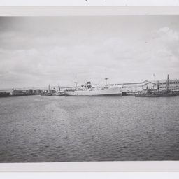
A ship at the No.2 berth at Port Adelaide. The Queen's Wharf is being reconstructed and the ship might be the 'Marjarta'. To see a selection of photographs in this collection, search on Archival number PRG 1642/13.


Remains of the 'Loch Tay'
Remains of the 'Loch Tay', last of the famous Loch Line. The keel was laid in 1869, and the hulk was left in this location in 1909. To see a selection of photographs in this collection, search on Archival number PRG 1642/13.


'Morialta' at dock
The 'Morialta' at a dock. To see a selection of photographs in this collection, search on Archival number PRG 1642/13.


Duke steppng ashore at Quay No. 1
The Duke stepping ashore from the Royal yacht Ophir at No. 1 Quay, Port Adelaide.


S.S. 'Dubbo'
The 'S.S. Dubbo' with the 'Coomonderry' astern at the No.12 berth. To see a selection of photographs in this collection, search on Archival number PRG 1642/13.


Ophir at Quay No. 1
Royal yacht Ophir at No. 1 Quay, Port Adelaide, from July 10-15, 1901. Taken from Birkenhead.


S.S. Tjipondok
View of the S.S. Tjipondok berthed at Port Adelaide. To see a selection of photographs in this collection, search on Archival number PRG 1642/13.


'Waipis' at Tragedy Dock
The 'Waipis' at Tragedy Dock. To see a selection of photographs in this collection, search on Archival number PRG 1642/13.


Ketch 'Mary'
The ketch 'Mary' at a dock. To see a selection of photographs in this collection, search on Archival number PRG 1642/13.


Schooner 'Milleeta'
The schooner 'Milleeta'. To see a selection of photographs in this collection, search on Archival number PRG 1642/13.


Sailboat
A sailboat or small yacht called 'Mazen', possibly at Port Adelaide. The initials 'P.A.S.C' are next to its name, possibly standing for 'Port Adelaide Sailing Club'. To see a selection of photographs in this collection, search on Archival number PRG 1642/13.


Lube process area, Adelaide Refinery
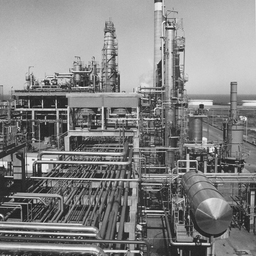
View of the Lube process area with hyrdofinisher, furfural unit, vacuum tower and chimney stack at the Adelaide Refinery at Port Stanvac.


Masters Four on River Murray
Annabelle (bow), Maggie, Cathy, Bev (str.) and Gill (cox) on the Murray River.


'Culwulla' boat
Small boat 'Culwulla' sailing, possibly near Port Adelaide.


Don and Sue Howell's party
Bev James and Peter Humble at Don and Sue Howell's party at West Lakes for the King's Cup Regatta.


Heavy lift at Outer Harbor, Port Adelaide.
Viewed from the Anro Adelaide at Outer Harbor, Port Adelaide, riggers prepare a heavy lift for loading onto the ship.


Campbell's heavy haulage Mack truck at Outer Harbor, Port Adelaide.
Viewed from the Anro Adelaide at Outer Harbor, Port Adelaide, a Campbell's heavy haulage Mack truck arrives at the Outer Harbour carrying a gas turbine generator manufactured by Detroit Engine & Turbine Company of Gepps Cross, part of a $3.3 million contract with Bangladesh.


D.M.H. work boats
After passing through the Birkenhead Bridge the Department of Marine and Harbors work boats 'Bareki' (nearest the camera) and 'Kowarra' propel a pontoon carrying workmen, a crane and a compressor. The Birkenhead Tavern is on the opposite bank.

![Plan of the District of Adelaide South Australia showing the property of the South Australian Company [cartographic material]](https://slsa-collections.s3.amazonaws.com/73/8f/18c0-43a9-5283-bcf5-d665d1ccc572.jpg)
Plan of the District of Adelaide South Australia showing the property of the South Australian Company [cartographic material]
Cadastral map of the 'District of Adelaide' with Adelaide, North Adelaide and surrounding parklands, Port Adelaide, Holdfast Bay and Glenelg down to the area just south of Marino, the rivers of the Adelaide plains and Port River, and the foothills of the Mount Lofty Ranges shown. The land sections are all numbered and those held by the South Australian Company coloured in green. Areas within the town grids for Adelaide and North Adelaide have been coloured in red. The map gives a clear indication of the extent of vegetation in 1838 across the Adelaide district. Scale 2 inches to 1 mile. Hand drawn map based on the survey by Light, Finniss & Co., with their company's name and the date October 1838 written in ink, at bottom centre of map. (This map came from the London office of the South Australian Company. It appears to predate the maps of the same area published in London by John Arrowsmith from February 1839 onwards).


Blue Steel reunion cake, South Australia
Cake at a Blue Steel reunion dinner at the South Australian Aviation Museum, Port Adelaide, South Australia.


Blue Steel Reunion cake, South Australia
Blue Steel reunion cake, South Australia Aviation Museum, Port Adelaide, South Australia. Next to the cake are pieces of a recovered Blue Steel rocket mounted on wood, they were presented to all attendees.


Men standing by the ketch 'Free Selector'
Copy of a photograph of group of nine men standing by the ketch 'Free Selector' being built in a shipyard, probably Port Adelaide. Written on reverse: 'Built 1875 in Port Adelaide for James Taylor. 1885 owned by Coombe and Delmont. 1890 owned by C.E. Delmont. 1893 owned by John Sherbourne Lashmar. Requisitioned by the U.S. Navy in 1941 and wrecked at Outer Harbor on 5 September 1942 when Uncle Jock (son of John Sherbourne Lashmar) had offered to pilot the vessel out of the harbour and he was not required! Caused a lot of grief to the Lashmar family.'


T.S.S. Kanowna
Postcard of T.S.S. Kanowna at the Port Adelaide wharf. Same photograph as B 10533 but not captioned.

![South Australia shewing the division into counties of the settled portions of the province with situation of mines of copper & lead [cartographic material] :
from the survey of Captn. Frome, Rl. Engrs., Survr. Genl. of the Colony, 1844 /
John Arrowsmith, 10 Soho Square](https://slsa-collections.s3.amazonaws.com/da/36/5540-01a4-5d21-9475-98e1e26f3f52.jpg)
South Australia shewing the division into counties of the settled portions of the province with situation of mines of copper & lead [cartographic material] : from the survey of Captn. Frome, Rl. Engrs., Survr. Genl. of the Colony, 1844 / John Arrowsmith, 10 Soho Square
Map of South Australia showing eight counties, towns and homesteads, roads and proposed railway tracks, mineral localities in red with notes on vegetation and land cover. The map also includes time-dated exploration routes. The inset of Port Adelaide shows streets and land blocks for proposed buildings. Surveys made in 1844. Relief is shown by hachures with some spot heights.
