Find • pirie street • Results 481 to 510 of 760


Locomotive at Port Pirie
Train standing in Ellen Street.

Locomotive at Port Pirie
A 5' 3" gauge train standing in Ellen Street.

Family photographs : Port Pirie
Main street showing railway station and institute.

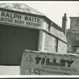
Chesser Street
Chesser Street, west side, 30th October 1964, right side of building is 13 yards south of French Street and frontage is 7 yards. The Salvation Army's People's Palace can be seen at the southern end of Chesser Street in Pirie Street. Some of the businesses on the western side of Chesser Street include Grant Industries (seatcovers and texile products), AG Thompson and Company, Tallerman at number 25, Shirley Perry (Interior Design). Most of these businesses are located with the Henry Austin Building

King William Street
King William Street looking north from Pirie Street 1866-1867. A street light on a stone pedestal stands in the middle of Currie and Grenfell Streets. Horses, carts and carriages are travelling along King William Street. Sparse housing can be seen across the river in North Adelaide.
![Adelaide plan.
surveyed and drawn for the Fire Underwriters' Association of South Australia by J.R. Ferguson
No. 24 [cartographic material] /](https://slsa-collections.s3.amazonaws.com/91/a5/0bf6-b795-585a-8e1f-2b6118e40f77.jpg)
Adelaide plan. surveyed and drawn for the Fire Underwriters' Association of South Australia by J.R. Ferguson No. 24 [cartographic material] /
Plan no. 24 of a set of fire insurance maps surveyed and drawn 1911-1914. This plan maps a portion of the City of Adelaide, South Australia showing land use including building usage, some street numbers and business names within the area of Pirie Street, Wyatt Street, Flinders Street and Pulteney Street.

King William Street near Currie Street
King William Street, west side. 15 February 1898. Right side of low two storey building is 24 1/2 yards south of Currie Street. Frontage of this building is 23 yards. The building (numbers 69 and 89) houses the businesses of Arthur Chapman and Company accountants and land agents, T Padman Sharebroker, ES Hughes Auctioneers, H Anders artistic hairdresser late of Pirie Street, J Todd Read Agent and Sharebroker, W Boyle house, land and estate agents. South of this building stands Colonial Mutual (Fire Marine Fidelity Guarantee, Plate Glass Accident, Employers Liability Insurance).

King William Street near Pirie Street
King William Street looking south. The photograph was taken between 1879-83. Adelaide Town Hall is dominant with the lack of a clock face prominent. Across the street stands the Post Office Building. There are horses and carriages lined up in the street patiently waiting for owners.
![Adelaide plan.
surveyed and drawn for the Fire Underwriters' Association of South Australia by J.R. Ferguson
No. 19 [cartographic material] /](https://slsa-collections.s3.amazonaws.com/71/77/f396-d90c-5b37-8379-2ed5170e9482.jpg)
Adelaide plan. surveyed and drawn for the Fire Underwriters' Association of South Australia by J.R. Ferguson No. 19 [cartographic material] /
Plan no. 19 of a set of fire insurance maps surveyed and drawn 1911-1914. This plan maps a portion of the City of Adelaide, South Australia showing land use including building usage, some street numbers and business names within the area of Grenfell Street, King William Street, Pirie Street and Gawler Place.
![Adelaide plan.
surveyed and drawn for the Fire Underwriters' Association of South Australia by J.R. Ferguson
No. 23 [cartographic material] /](https://slsa-collections.s3.amazonaws.com/11/e4/a047-a1b1-57f1-a4c4-181583f9a9f3.jpg)
Adelaide plan. surveyed and drawn for the Fire Underwriters' Association of South Australia by J.R. Ferguson No. 23 [cartographic material] /
Plan no. 23 of a set of fire insurance maps surveyed and drawn 1911-1914. This plan maps a portion of the City of Adelaide, South Australia showing land use including building usage, some street numbers and business names within the area of Pirie Street, Flinders Street and Wyatt Street.

Hindley Street looking east
[General description] Lithograph of an S.T. Gill sketch, from'Views in Adelaide No. 2'. Shows Hindley Street looking east, with city buildings on either side of the unsealed road. The two storey Phoenix hotel on the right (on the east corner of Clarendon Street) was established in 1850 and the licensee from 1850-52 was R. Hall. The Royal Oak and Miner's Arms Hotel can be seen on the left of the picture, with a partial view of the Clarendon Hotel further east. Printed and published by Penman & Galbraith, Pirie Street, Adelaide. [On back of photograph] 'Acres 56,57, 68,69 / 1851 / For other letterhead specimans see B 4198 / B 2430 / Presented by Miss. P.E. Leftwich, London. 6/8/1947.' No.2 in a series (see B 4198 for no.1 and B 2430 for no.3).

Commonwealth Bank construction, King William Street, Adelaide
Commonwealth Banking Corporation office building construction. King William Street, east side, 4th June 1981, frontage of building is 50.2 metres, right side of building is 41.6 mtres north of Pirie Street and left side of building is 441.6 metres south of Grenfell Street.

Scotch Kirk, Grenfell Street
Photograph of James Shaw's oil painting of Grenfell Street, south side, with St Andrew's Presbyterian Church behind its picket fence, from a painting in a private collection. The foundation stone of the church was laid in February 1844 and opened in July that year. It was demolished in 1893. It had a seating capacity of 250, with a bell of Burra copper hung in 1845. Notes on the back of the photograph state "Grenfell Street, south side. Acres 141 and 142. Church of Scotland (St Andrew's) about 1852. Church completed in 1844. Wesleyan Church, Pirie Street (shown in the view) completed in 1851".

Wyatt Street, Adelaide
[General description] This is a new warehouse for the grocery firm Wilkinson & Co. Ltd. [On back of photograph] 'Acre 165 / Wyatt Street, west side / March 15th 1954 / Left side of Wilkinson's building is 33 yards north of Pirie Street / Frontage 16 yards / Wilkinson's building was completed in 1952 / For view showing galvanised iron structure formerly on the site, see extreme right of B 85 / Note: This building continues through to Chesser Street (see B 13040)'

Chesser Street
Chesser Street, east side, March 15th 1954. Right side of white cement building is 45 yards north of Pirie Street. Frontage of building is 12.75 yards. This building was completed in 1952. For view of galvanised iron building formerly on this site see B 5741. Note: this building continues through to Wyatt Street (see B 13094)

Coromandel Street
Coromandel Street, East Side, 28 January 1972, Coromandel Street frontage is 33 1/3 yards and Pirie Street frontage is 11 2/3 yards.

King William Street, Adelaide
[General description] City buildings and cars in King William Street with a fruit barrow at the kerb. Businesses are: The Majestic Theatre; Mick McCoy Ltd, a leathergoods and saddlery shop and Travelware on the ground floor of Ware Chambers [On back of photograph] 'Acre 170 / King William Street, east side / 1954 / Right side of McCoy's building is 39 yards north of Pirie Street and frontage is 7 yards / This building was remodelled in 1955 / Compare with B 13606'

King William Street
Northern corner of King William Street and Pirie Street before 1878 showing South Australian Insurance Company building. Insurance Chambers on the corner of King William Street from 1876 provided offices for merchants, land agents, a solicitor and the Kadina and Wallaroo Railway Company. Architect James MacGeorge placed heavy rusticated stone decorations around the ground floor windows. The building was demolished in 1953

Commonwealth Bank and Warner Theatre, King William Street, Adelaide.
King William Street, East Side, 24th January 1980, right side of Warner Theatre is 46 1/3 yards north of Pirie Street and frontage is 48 yards. Sign on the Warner Theatre says "Come - Say goodbye to the Warner!! Closing early Feb". A Union Jack flag is flying from a flag pole in the middle of King William Street.

King William Street
King William Street looking south with Pirie Street corner on the left. Only a few pedestrians are out and about. Carriages and covered carts are using the street. The Town Hall clock face is bare. The clock on the Post Office tower says ten minutes to eleven in the morning.Three men in top hats are having a discussion in the foreground.
Hyde Street
South west corner of Hyde Street and lane off west side of Hyde Street, 24th October 1957, right side of building is 34.5 yards south from Pirie Street. For frontage of building see B 13940

Pulteney Street, Adelaide
St. Paul's Church, north east corner of Pulteney Street and Flinders Street, Adelaide. The extreme left is 57 yards south of Pirie Street.

Ware Chambers, King William Street, Adelaide
Premises of Ware Chambers and Muirden College on the North East corner of King William Street and Pirie Street, Adelaide, with pedestrians crossing the street and a cyclist moving through the intersection.

Two men talking on the streets of Adelaide
Two men identified as J.C. Haag (left) and A.M. Simpson talking after an encounter in the streets of Adelaide. Location is King William Street. The Royal Exchange building in the background was between Grenfell and Pirie streets.
![Adelaide plan.
surveyed and drawn for the Fire Underwriters' Association of South Australia by J.R. Ferguson
No. 20 [cartographic material] /](https://slsa-collections.s3.amazonaws.com/f2/1f/0c0e-dae7-5289-951b-7f406f3199b0.jpg)
Adelaide plan. surveyed and drawn for the Fire Underwriters' Association of South Australia by J.R. Ferguson No. 20 [cartographic material] /
Plan no. 20 of a set of fire insurance maps surveyed and drawn 1911-1914. This plan maps a portion of the City of Adelaide, South Australia showing land use including building usage, some street numbers and business names within the area of Grenfell Street, Gawler Place, Pirie Street and Hindmarsh Square.
![Adelaide plan.
surveyed and drawn for the Fire Underwriters' Association of South Australia by J.R. Ferguson
No. 21 [cartographic material] /](https://slsa-collections.s3.amazonaws.com/f3/79/6b60-411a-5c18-90d3-4001c263747b.jpg)
Adelaide plan. surveyed and drawn for the Fire Underwriters' Association of South Australia by J.R. Ferguson No. 21 [cartographic material] /
Plan no. 21 of a set of fire insurance maps surveyed and drawn 1911-1914. This plan maps a portion of the City of Adelaide, South Australia showing land use including building usage, some street numbers and business names within the area of Grenfell Street, Hindmarsh Square, Pirie Street, Mogar Lane and Tam O'Shanter Place.

Chesser Street
Chesser Street, east side, 14 February 1969, right side of building is 75 yards north of Pirie Street and frontage is 16 1/3 yards.

Chesser Street
Chesser Street, east side, 14 February 1969, right side of building is 75 yards north of Pirie Street and frontage is 16 1/3 yards.

Hyde Street, Adelaide
Hyde Street, Adelaide, west side. This photo, taken in July, 1915, features the premises of William Cornell & Sons. Bicycles and motorcycles are displayed in the store windows. Two men in a tourer are parked out the front. The south end of Cornell's is 20 yards from Pirie Street.

Hyde Street
Hyde Street, west side, left side of building is 43 yards north of Pirie Street.