Find • port • Results 15,991 to 16,020 of 16,172

![South Australia. Map of Yorkes Peninsula [cartographic material] /
compiled from Government plans, and the most reliable private information that could be obtained](https://slsa-collections.s3.amazonaws.com/a4/30/4429-e0ed-525d-9eca-f5e1c6dcb301.jpg)
South Australia. Map of Yorkes Peninsula [cartographic material] / compiled from Government plans, and the most reliable private information that could be obtained
Map of Yorke Peninsula, South Australia, compiled from government plans and the most reliable private information that could be obtained. Shows mineral sections of Black Point, Tipara, Wallaroo and Kulpara. Gives number, size and some dates for pastoral leases, as well as names of the lease holders. Includes some notes on natural features, text on sections formed into companies and sections not formed into companies. Coast and rivers hand coloured blue. Relief shown by hachures and pictorially.
![Glenelg - Clarendon area [cartographic material] /
compiled from Reconnaissance surveys by W.H. Edmunds](https://slsa-collections.s3.amazonaws.com/ad/a5/30ad-5428-53a6-a4c7-28a52fe493ef.jpg)
Glenelg - Clarendon area [cartographic material] / compiled from Reconnaissance surveys by W.H. Edmunds
Topographic map of the Glenelg to Clarendon area, from the Patawalonga Creek in the north west, Mount Osmond in the north east, Port Noarlunga in the south west and Kangarilla in the south east. Details include roads, petrol supply, churches, hotels, power works & factories, orchards & vineyards, railways, tramways, houses and Happy Valley and Mt. Bold reservoirs.
![South Australian railways [cartographic material] :
map to accompany time and fare tables November 1915](https://slsa-collections.s3.amazonaws.com/c7/fb/eed3-c8cd-53f5-91ef-05965dc95415.jpg)
South Australian railways [cartographic material] : map to accompany time and fare tables November 1915
Map of South Australia showing railways, the different gauge lines, lines under construction (Port Augusta to Kalgoorlie), the private line from Iron Knob, the northern lline to Oodnadatta, the Overland Telegraph Line, place and station names and some geographic features.
![Map shewing lines of railways in South Australia 1903 [cartographic material]](https://slsa-collections.s3.amazonaws.com/a7/da/3671-df11-5e00-adbe-7c43c20af264.jpg)
Map shewing lines of railways in South Australia 1903 [cartographic material]
Map of South Australia, showing railway lines and different gauges, place names and geographical features. Also shows suggested route from Port Augusta to Kalgoorlie, the private railway from Iron Knob to Spencer Gulf and north of Oodnadatta, the proposed railway line to the Northern Territory and the route of the Overland Telegraph.

RMS 'Stratheden' at Outer Harbor
Colour slides of RMS 'Stratheden' on her last voyage at Outer Harbor, Port Adelaide on 25th April 1962 including 1. Side view of the ship and 2. Flying 'Paving off' Pennant.
Papers of Julia Coleridge Farr
Papers of Julia Clinton Farr. See 'contents' for details of envelopes.
![South Australia. A survey of the coast on the east side of St. Vincents Gulf made by Colonel Light [cartographic material]](https://slsa-collections.s3.amazonaws.com/60/73/847d-985b-5ff1-ae86-82009307c934.jpg)
South Australia. A survey of the coast on the east side of St. Vincents Gulf made by Colonel Light [cartographic material]
Chart of eastern side of St. Vincent Gulf from Rapid Bay north to Port Noarlunga with description of topography. Relief shown by bathymetric soundings and hachures.
![E.S. Wigg & Son's general map of the Barrier Ranges mineral fields, (silver, tin etc.) [cartographic material] /
compiled by W.H. Tietkins & R. Garlick Holwell](https://slsa-collections.s3.amazonaws.com/8d/16/da93-91a7-5db3-990f-756d1db46f93.jpg)
E.S. Wigg & Son's general map of the Barrier Ranges mineral fields, (silver, tin etc.) [cartographic material] / compiled by W.H. Tietkins & R. Garlick Holwell
Topographical map of the Barrier Ranges mineral fields, New South Wales. Index to mines at Broken Hill, Euriowie, Thackaringa, Pinnacles, Rockwell Paddock, Waukaroo Relief shown by hachures. Map was among the papers of Professor J.B. Cleland.
South Australian politicians at various events
A collection of photographs of people and events associated with South Australian politicians. In addition to the photographs, it also includes a number of photocopied pages with additional photos and the captions which were used with the images (items 68-79), and a 35mm slide of an unidentified man (item 80). A selection have been digitised and may be viewed online (do an ARCHIVAL NUMBER search on B 71858); the rest may requested and viewed in the Reading Room.
![Plan of the township of Two Wells South [cartographic material] :
section 449, Hundred of Port Gawler /
T.W. Lyons, Draftsman](https://slsa-collections.s3.amazonaws.com/43/2f/d89e-fdc4-599f-a150-2564b087aea4.jpg)
Plan of the township of Two Wells South [cartographic material] : section 449, Hundred of Port Gawler / T.W. Lyons, Draftsman
Plan of the township of Two Wells, South Australia. Details include street names and lot numbers, measurements and prices. No relief shown.
![Part of South Australia [cartographic material] /
the map drawn & engraved by J. Rapkin; the illustrations by H. Warren & engraved by J. Rogers](https://slsa-collections.s3.amazonaws.com/e6/4d/798e-29b3-533c-a36c-6bc198cde1e8.jpg)
Part of South Australia [cartographic material] / the map drawn & engraved by J. Rapkin; the illustrations by H. Warren & engraved by J. Rogers
Lithographed map of part of South Australia from Lake Torrens to Kangaroo Island with place names and named features, and showing counties and mining districts. Mapping of the coast from Elliston in the west to the Coorong in the east, and from Kangaroo Island in the south to Mt. Deception in the north. The depiction of Lake Torrens indicates exploration not very advanced at this date. Originally published within 'Tallis's illustrated atlas and modern history of the world'. London : John Tallis & Company, 1851. Also published as plate 13 of Martin's 'Australia, comprising New South Wales, Victoria or Port Philip, South Australia and Western Australia : their history, topography, conditions, resources, statistics, gold discoveries, mines of copper, lead etc. London. J. Tallis and Co., [1853?]. A State Library Tallis map "Part of South Australia" 1851 (call no. rbr 325032) was flown in space aboard the United States Space Shuttle "Discovery" with the South Australian astronaut Andy Thomas. "Discovery "was launched at 10:39 a.m. EDT., July 26, 2005, from the Kennedy Space Center, Florida.

PS Murray Princess at Mary Ann Reserve
People standing on the bank of the river near the paddle steamer PS Murray Princess at Mary Ann Reserve, Mannum, with 'Randall's boiler' in view.

John Mellor's expedition photographs
Photographs of expeditions and excursions to River Murray, Eyre Peninsula, Islands of Bass Strait, Capricorn Islands and outback locations.

Proofing of A.75 Anti Aircraft gun at Port Wakefield
Man operating the weapon.

Proofing of A.75 Anti Aircraft gun at Port Wakefield
With clouds in the sky.

Motor tow boat being transported to Port from Woodville Plant
Dory boat on trailer, with sign 'Trench No. 83, D1' in the background; Boat on trailer, with lettering 'USA-D-No.343' on the bow, driving past Plant and 'W.C.Bourn, Hindmarsh' on trailer; boat on cradle; Boat and cradle being loaded by crane onto 'J.T.R.E

Motor tow boat sea trials at Port Adelaide
Testing a newly built Dory boat.

Motor tow boat sea trials at Port Adelaide
Testing a newly built Dory boat.

Seven Dory boats in line
Boat numbers AM1649, AM1646, AM1648, AM1651, AM1652, AM1650 and AM1656 in the Port Adelaide River near the Birkenhead Plant. Adelaide Milling Co. in view behind.

View of diecaster plant, Diecasters Pty. Ltd, Port Road, Allenby Gardens

GMH Woodville Port gate
Front view.

Mason & Cox Plant views
Views inside the Mason & Cox steel foundry. A researcher suggests that Mason and Cox were at Anderson Street Thebarton before moving to Haywood Ave. Torrensville from about 1967-1975. 'The Adelaide government wanted to put a north-south road corridor as a widening to the Port Road. With government assistance, The Torrensville land was purchased about 1966, buildings were established and then machinery was moved over the next 7-8 years.'

GMH Fishermen's Bend Plant opening ceremony
Part of volume five of a group of photographs documenting construction of Holden's Fishermen's Bend Plant at Port Melbourne, Victoria. Comprises views of the opening ceremony.

GMH Fishermen's Bend Plant construction and opening
Part of volume five of a group of photographs documenting construction of Holden's Fishermen's Bend Plant at Port Melbourne, Victoria. Comprises views of the laying of the foundation stone of the GMH Plant and construction of NASCO buildings.

GMH Fishermen's Bend Plant construction
Volume five of a group of photographs documenting construction of Holden's Fishermen's Bend Plant at Port Melbourne, Victoria. Comprises views of buildings at Fishermen's Bend prior to the construction of the General Motors-Holden's Limited plant.
Paintings by George Gawler and J.M. Skipper
Nine watercolour sketches, variously attributed to George Gawler and J.M.Skipper. They include Government House, Hack's Farm, Port Lincoln, Lake Alexandrina and the Murray River. Individual records can be viewed by doing a NUMBER search on PRG 50/34.

Hindmarsh River, Port Victor
View of the Hindmarsh River at Victor Harbor, looking up towards 'Adare'.

Field service postcard from Ross Smith to his mother
Standard field service postcard from Ross to his mother, Jessie Smith, during his active service in World War I. Posted from Port Said 4th Australian Infantry Brigade field post office on 25 July 1915.

Letter from Ross Smith in World War I camp, Egypt, to his mother
Letter from Ross to his mother, Jessie Smith, from camp in Egypt during his active service during World War I. Mentions leave taken in Cairo, Keith's intention to travel to Port Said, and other happenings.
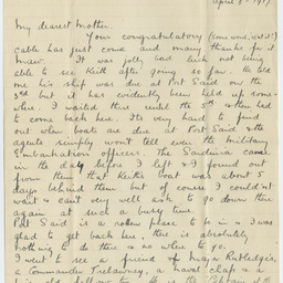
Letter from Ross Smith in World War I camp, Egypt, to his mother
Letter from Ross to his mother, Jessie Smith, from camp in Egypt during his active service during World War I. With mention of frustration at missing a meeting with brother Keith in Port Said.