Find • largs • Results 4,831 to 4,860 of 4,861


Series 033: Holden plants
Aerial images of Holden's Motor Body Builders, later General Motors-Holden, plants at Woodville and Beverley. Photographs include views of Port Road, Cheltenham Parade, Cheltenham Racecourse, the Actil Factory and Woodville High School.

Series 041: Aerial views around greater Adelaide
Aerial views of various locations around Adelaide, including photographs of the city and buildings at Mile End South, Goodwood, Birkenhead and the river at Castambul.

Series 029b: Early aeroplanes
Photographs of aeroplanes, believed to be at Parafield Airport, over a number of years. Planes depicted include those flown by Bert Hinkler, Sir Alan Cobham, and Major de Havilland.

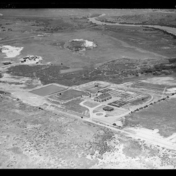
Series 087b: General Motors Australia, Birkenhead
Aerial views of the General Motors Australia plant at Birkenhead, adjacent to the Port River.

Series 162b: Planes and people at Parafield
Photographs of aeroplanes, crowds and individual people at Parafield Airport, likely relating to an Aero Club event.

Series 049a: Aerial views of Adelaide
Aerial photographs of Adelaide, showing various views around the CBD and adjacent to the River Torrens. Featured buildings and sites include Adelaide Oval, Government House, Parliament House, Adelaide Railway Station, King William Street, King William Road, North Adelaide, University of Adelaide, Adelaide Zoo, Albert Bridge, Morphett Street Bridge, and distant views of the south eastern suburbs and Mount Lofty Ranges.

Series 072: Onkaparinga Woollen Mills, Lobethal
Aerial views of the Onkaparinga Woollen Mills at Lobethal, taken from various heights and directions. Lobethal and Woodside Roads can be seen in the photographs.

Series 073: Glenelg Sewage Treatment Works
Aerial photographs of the Glenelg Sewage Treatment Works (later the Glenelg Wastewater Treatment Plant), between Military Road and the beach at Glenelg North. The site comprises a main building, several smaller outbuildings, open treatment ponds, a water tower, and a house. The site is surrounded by sand dunes and low coastal shrubs, and on the dunes facing the sea are a large number of shacks.

Series 074: Hamilton's Ewell Vineyards
Aerial views of Hamilton's Ewell Vineyards on the corner of Morphett Road and Adelaide Road (later Oaklands Road) at East Glenelg (later Glengowrie). The winery buildings are surrounded by extensive vineyards on both sides of Morphett Road. A sign painted on the main building reads 'Hamiltons Ewell Vineyards Ltd Vignerons Distillers'.

Port Broughton Hotel, Port Broughton
Port Broughton Hotel, with a large number of people outside celebrating a fancy dress football carnival. See B 15363 for more information about the event.

Unidentified hotel
Convoy of cars outside of a large 2 storey hotel, possibly in Kapunda. The building is labelled 'Hulbert's'.

Unidentified building
View of a large low-level building, possibly 'Davis's'. A street sign appears to say 'To Adelaide'.

Series 077: ANZAC Day Parade, 1936
Aerial photographs of the 1936 Anzac Day Parade from King William Road towards the Cross of Sacrifice in lower North Adelaide. Views include City Bridge, the River Torrens, Adelaide Oval, Jolley's Boathouse, St Peter's Cathedral, Pennington Terrace and the Torrens Parade Ground.

Series 083: Aerial views of Adelaide
Aerial views of the city of Adelaide, largely showing the area around North Terrace and King William Street.

Series 098: Aerial views of P&O ships at Outer Harbor
Aerial views of P&O ships, 'Strathaird' and 'Stratheden' at Outer Harbor. Some images include distant views of suburbs around Largs and views along the coast south of Outer Harbor.

Series 105: Aerial views of country towns
Aerial views of country towns and locations around South Australia including Birdwood, Murray Bridge, Mannum, Tailem Bend, Gumeracha, Athelstone, Berri, Strathalbyn, and Palmer.

Series 108: Aerial photographs of Penfolds Winery at Magill and Nuriootpa
Aerial views of Penfolds Winery buldings and vineyards at Magill and Nuriootpa during the 1930s.

Series 109: Aerial views of Kelvinator factory at Ashford
Aerial photographs of the Kelvinator Australia Limited factory at Ashford, bounded by Anzac Highway, Everard Avenue and Day Avenue, and surrounding premises including parts of the Keswick Barracks and houses in Ashford and Keswick.

Series 0529: Gamblings Ltd staff picnic
Group photographs of a large number of employees of Gamblings Ltd and their families, posed by a lake at a staff picnic.

Series 0775: City Motors staff
Group photograph of staff at City Motors, taken in a large warehouse.

Series 1344: Farmers Union Egg Floor building
Photograph of a print on a pinboard, showing a view of the exterior of a South Australian Farmers' Coop Union building. A large sign reads 'Farmers Union Egg Floor'.

Series 1363: Burns Philp interior
Interior view of a large industrial building, showing a floor covered in metal parts. The photographer's label suggests it relates to Burns Philp.

Series 1536: Second year medical students
Large group photograph of second year medical students at the University of Adelaide, taken in front of Bonython Hall.

Series 1821: Second year medical students
Large group photographs of second year medical students at the University of Adelaide, taken in front of Bonython Hall.

Series 2083: Second year medical students
Large group photographs of second year medical students at the University of Adelaide.

Series 2379: Second year medical students
Large group photographs of second year medical students at the University of Adelaide.

Families heading to the 89th Adelaide Christmas Pageant at Adelaide Oval
Families heading across the grass to the 89th Adelaide Christmas Pageant at Adelaide Oval. Large floats can be seen in the background. The event was held at Adelaide Oval instead of the Adelaide City streets to control the capacity of the event due to the COVID-19 pandemic, for the second year in a row.

Series 127: Aerial views of Barossa Valley towns
Aerial views around the Barossa Valley, including views of wineries, vineyards and towns. Includes photographs of Chateau Tanunda, Lyndoch, and buildings at Nuriootpa.
Series 135: Port Adelaide Wastewater Treatment Plant
Aerial photographs of the Port Adelaide Wastewater Treatment Plant on Frederick Road, at what later became West Lakes. Port Creek is in the background.The processing plant buildings, two large tanks and a water tower can be seen in the images.

Series 144: Aerial views of breweries and other businesses
Aerial photographs of Walkerville Brewery at Thebarton, the Lion Brewery and Hotel at North Adelaide, the West End Brewery in Adelaide, and Coopers Brewery at Leabrook. Also includes images of Tolley, Scott & Tolley Ltd. winemakers and distillers at Stepney, and the premises of pharmaceutical firm F.H.Faulding and Co at Thebarton.