Series 144: Aerial views of breweries and other businesses [BRG 397/2/144] • Photograph

Item 01: Aerial view of Walkerville Brewery, Thebarton.
Aerial photograph of Walkerville Brewery at Thebarton, looking north east. The image features a large chimney and the Walkerville Brewhouse Tower. The Brewery is bordered by Port Road, Adam Street, the River Torrens and Park Terrace. The site was later owned by the South Australian Brewing Company.

Item 02-03: Aerial views of the Lion Brewery, North Adelaide.
Aerial photographs of the Lion Brewery and the Lion Hotel on the corner of Melbourne Street and Jerningham Street, North Adelaide. The images show surrounding houses and streets including Finniss Street and MacKinnon Parade.

Item 02-03: Aerial views of the Lion Brewery, North Adelaide.
Aerial photographs of the Lion Brewery and the Lion Hotel on the corner of Melbourne Street and Jerningham Street, North Adelaide. The images show surrounding houses and streets including Finniss Street and MacKinnon Parade.

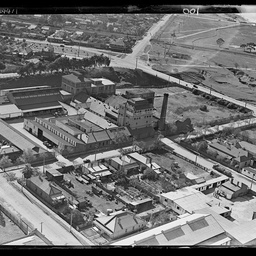
Item 04-05: Aerial photographs of West End Brewery, Hindley Street.
Aerial photographs of West End Brewery on the corner of Gray and Hindley Streets, Adelaide. Nearby houses and businesses along Currie Street and Hindley Street can be seen, and the Currie Street School (later part of the Adelaide Remand Centre) is adjacent to the Brewery.

Item 06-08: Aerial views of Coopers Brewery, Leabrook.
Aerial photographs of Coopers Brewery on Statenborough Street at Leabrook. Surrounding houses, including along Bretwalder Avenue and Stanley Street, can also be seen.

Item 06-08: Aerial views of Coopers Brewery, Leabrook.
Aerial photographs of Coopers Brewery on Statenborough Street at Leabrook. Surrounding houses, including along Bretwalder Avenue and Stanley Street, can also be seen.

Item 06-08: Aerial views of Coopers Brewery, Leabrook.
Aerial photographs of Coopers Brewery on Statenborough Street at Leabrook. Surrounding houses, including along Bretwalder Avenue and Stanley Street, can also be seen.

Item 09: Aerial view of Tolley, Scott & Tolley Ltd, Stepney.
Aerial photograph of the premises of Tolley, Scott & Tolley Ltd, winemakers and distillers, on Nelson Street and Henry Street at Stepney. The photograph is taken looking west and shows several surrounding houses.

Item 10: Aerial view of F. H. Faulding and Co, Thebarton.
Aerial photograph of the premises of F. H. Faulding and Co on Stirling Street at Thebarton. The River Torrens and Adam Street are in the background of the photograph.