Find • bank of adelaide • Results 661 to 690 of 1,060


Adelaide, West Parklands
A view from the West Parklands (Bonython Park) looking east towards the hills. The scene is taken up with the grassed banks of the River Torrens, with a flock of seagulls perched on the eastern side and the old railway bridge with a cargo train in transit. An outline of the buildings of Adelaide can be seen to the right with the Adelaide Hills taking the background.

Postcard views of South Australia
Twenty nine postcards depicting scenes around South Australia. Locations include Victor Harbor, Adelaide, Blanchtown, Crafers, Clarendon, Belair National Park, Largs Bay, Glenelg, Mount Lofty and Unley. Contents include SS 'Riverina', horse drawn vehicles, shearing, railway stations, beaches, and buildings. Many are tinted.

1971 Christmas Pageant
Father Christmas on a float during the 1971 Christmas Pageant, passing the Commercial Bank of Australia building at 21 King William Street.

Pageant Official tabard
Lime green cotton tabard vest with tie fastener on each side, owned by John Martin's staff member Beverley Tripodi. On one side is printed 'Pageant Official' and the logos of John Martin's and the State Bank. One the other side is a small image of two clowns and the phrase 'Partners in the Pageant'.

Mill, Hindmarsh
Thomas Magarey's Mill and cottage, between Manton and Roberts Streets Hindmarsh, facing the River Torrens. The Mill was demolished about 1903, it incorporated some of John Ridley's Mill machinery. Thomas Magarey [1825-1902] was a businessman and Churches of Christ founder in South Australia. In 1845 he settled at Noarlunga and managed a flour mill. In 1850 he bought John Ridley's flour mill at Hindmarsh. He was a successful businessman and built a large house at Enfield which boasted a Turkish bath and telescope to study the stars. He was founding shareholder of the Bank of Adelaide, part owner of "The Register", founding member of the Adelaide Club and member of both Lower and Upper Houses. The photograph shows the mill with its rounded iron roof, a house and a tall brick chimney.

Mill, Hindmarsh
Magarey's Mill, Hindmarsh just before demolition. The Mill was demolished about 1903, it incorporated some of John Ridley's Mill machinery. Thomas Magarey [1825-1902] was a businessman and Churches of Christ founder in South Australia. In 1845 he settled at Noarlunga and managed a flour mill. In 1850 he bought John Ridley's flour mill at Hindmarsh. He was a successful businessman and built a large house at Enfield which boasted a Turkish bath and telescope to study the stars. He was founding shareholder of the Bank of Adelaide, part owner of "The Register", founding member of the Adelaide Club and member of both Lower and Upper Houses. The photograph shows the Torrens Road three storey mill with its delapidated out houses. The chimney is still standing. For site see B 7420.

Mill, Hindmarsh
Magarey's Mill, Hindmarsh just before demolition. The Mill was demolished about 1903, it incorporated some of John Ridley's Mill machinery. Thomas Magarey [1825-1902] was a businessman and Churches of Christ founder in South Australia. In 1845 he settled at Noarlunga and managed a flour mill. In 1850 he bought John Ridley's flour mill at Hindmarsh. He was a successful businessman and built a large house at Enfield which boasted a Turkish bath and telescope to study the stars. He was founding shareholder of the Bank of Adelaide, part owner of "The Register", founding member of the Adelaide Club and member of both Lower and Upper Houses. The photograph shows the three storey mill with its delapidated out houses. The chimney is still standing.

Early Lameroo identities
Early Lameroo identities. Back row, left to right: Mr Edwards (teacher); Alfred Townsend; Lou Conrad (butcher); William Muir MacFarlane; J. McNamara (agent and auctioneer); R.A. O'Connor (general storekeeper); James Cameron (blacksmith); James Messenger. Front row: ? ; Dr Dunstone; H.W. Skinner (Bank of Adelaide manager); William J. Ryan (police officer); R.F. Murphy (general storekeeper); Rev. Tilbrook.

Floods at Mannum
Flood conditions at Mannum, showing the Institute, Bank of Adelaide & Bakery. Contained in "Mannum Hospital Flood Souvenir, 1870-1956".

Murat Bay Township
Murat Bay township showing right to left: Institute Hall; Bank of Adelaide; Methodist Church; iron house in the foreground which belonged to the resident nurse.

Rundle Street, Adelaide
Rundle Street, Adelaide, north side on 20th March, 1923. Kuhnel Pianos', a Bargain Shoe Store and Metters Limited, makers of ovens and kitchen ranges, can be seen. The National Bank building, which stands on the south east corner of the acre, was demolished in May, 1923. For a view of the building subsequently erected on this site see B 2293. For a view of the Metters Building in 1958, see B 14045.

King William Street
Bank of Adelaide, King William Street.

Adelaide
View of Adelaide looking south east from the "Register" tower, Grenfell Street between 1863 and 1867. The view shows empty paddocks with washing lines billowing in the wind on the acres between Grenfell Street and Pirie Street. The spire of the Evangelical Lutheran Bethlehem Church in Flinders Street can be seen to the right of the photograph. A researcher suggests that the buildings are the Union Bank of Australia, then the manse, side of Wesleyan Methodist Church and that the spire is St. Andrews.

The Torrens Boathouses
Boathouses on the banks of the River Torrens.

Fireworks by the lake
Setting up fireworks on the banks of Torrens Lake for a Henley on Torrens display.

Holbrook Wine Cellars, Underdale
One of 7 photographs of Holbrook Wine Cellars, Underdale (B 69058/9 - B 69058/15). This photograph shows the original two sections of Holbrook Wine Cellars, built by J.D. Holbrook on his property, Wilford Vineyards, on the southern bank of the River Torrens. Photo taken from Holbrooks Road, Underdale, near Underdale Bridge. Photographed 7 May 1989.

Holbrook Wine Cellars, Underdale
One of 7 photographs of Holbrook Wine Cellars, Underdale (B 69058/9 - B 69058/15). This photograph of the two original sections before the north section was demolished. Photograph taken from the north bank of River Torrens on 13 May 1989.

Gustav Dohse and his prize horse 'Ruby'
Photograph showing Gustav Dohse (in hat) with his prize horse 'Ruby' at Balaklava. The Bank of Adelaide building is in the background.

A motor car stand, Adelaide, South Australia
A line of cars parked in Currie Street outside the Bank of Australasia, with the entrance to Gilbert Place behind them, and part of the Commercial Chambers (housing the 'Gadfly' newspaper) beyond that. These are Hire cars registered with the Adelaide City Council. Second in the line is De Dion No.1 owned by Jason Murphy, then a darracq No.11 owned by G.B. Woodman, followed by another Darracq No.2 owned by William Oliver, then Charles gilbert's De Dion No.9. Information courtesy of the veteran Car Club of SA

Photographs of 1927 tour from Wilpena to Yadlamalka
Photographs of 1927 tour by three cars from Wilpena in the Flinders Ranges (12 May) to Yadlamalka, some 60 kilometres north of Port Augusta (2 June), via Innamincka There are detailed captions typed on the verso of each photograph, with the only clue to the identity of the party coming from one of them (17 May): 'Members of the Commission with Doctor in Charge ... of Paralana Hot Springs Sanatorium'.
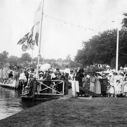
Spectators at the Henley on Torrens Regatta
Spectators crowded onto a landing jetty and along the banks of the River Torrens during the annual regatta held on 'Henley on Torrens' day; a feature were floral decorated boats which can be seen nearby.

Parliamentary tour of Eyre Peninsula, October 9-18, 1926
Small album comprising 49 black and white photographs showing the highlights of the Parliamentary Tour of Eyre Peninsula from the 9th to the 18th of October 1926. The tour of the West Coast of the Eyre Peninsula was to inspect railway, shipping, water, and other facilities. Photographs by E. Morris, The Register. For more details and list of members on the tour see article 'Parliamentary visit to Eyre Peninsula' in 'The Advertiser', Monday 11 October 1926, page 13. See below for details of images.
![Map of South Australia [cartographic material] /
by G. Hunckel](https://slsa-collections.s3.amazonaws.com/c3/ea/c1bd-547b-5c48-bf30-293a615784b2.jpg)
Map of South Australia [cartographic material] / by G. Hunckel
Map of Adelaide, Gulf of St. Vincent and part of Kangaroo Island with shaded part of map showing surveyed lands. Enclosed is an inset map of Australia. Above the map is a sketch of Adelaide showing North Terrace and the River Torrens with Aboriginals camped on the river bank.

Ladies Boating Club
Members of the Ladies boating club. There are eleven women in the photograph, sitting on the bank of the River Torrens with a row boat. Two Union Jack flags have been placed behind them.

King William Street
King William Street west side looking north towards Currie Street, 1868-72. The Bank of Australasia is prominent in the centre of the view. Reproduced in 1925 from a faded original.

King William Road
King William Road looking from a point a little north of the City Bridge. The rotunda in Elder Park can be seen on the opposite bank of the River Torrens along with Parliament House and the City Baths

Mounted Police Barracks
Mounted Police barracks, stables, etc. looking south from the north bank of the Torrens. The stables comprise the single storey structure shown in the top centre. The barracks were finished in 1851 and comprised of an armoury and residential accommodation. The upper level was added in the mid 1880's.

River Torrens parklands
Buildings and parklands between North Terrace East, Frome Road., & River Torrens. Looking south west from a point a little west of the Albert Bridge. The newly opened Public Library building can be seen in the distance together with the New Colonial Store building which was erected in 1867. The photograph shows men rowing on the lake with the steep banks of the lake in the background.

Students in Prosh procession
Students sitting on a float as it passes the Bank of New South Wales building on North Terrace. A female student holds a copy of the University newspaper 'On Dit' and waves to the photographer.

Floods at Mannum
Flood water in Randell Street. Buildings shown, at the peak of the flood, include the Bank of Adelaide, Borman's bakery, the flour mill and the Mannum Hotel.