Find • adelaide aerial • Results 1 to 30 of 653


Aerial photographs of Adelaide CBD
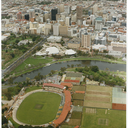
Aerial views of Adelaide CBD, taken in 2007. See below for details.

Series 007: Aerial view of Adelaide Chemical and Fertilizer Company premises
Aerial photographs showing the Adelaide Chemical and Fertilizer Company and surrounding areas at Port Adelaide and Torrensville.

Series 088: Aerial photographs of South Australian gaols
Aerial views of Adelaide Gaol, Yatala Labour Prison, Gladstone Gaol and one image of the Thebarton Police Barracks.

Album of aerial photographs
Album of photographs, mostly by Adelaide aerial photographer D. Darian Smith. Includes views of western and coastal suburbs of Adelaide, and ships at Port Victoria.

Series 099: Aerial views near St Peter's Cathedral
Aerial views of part of North Adelaide near St Peter's Cathedral and the Memorial Hospital. The images also show Sir Edwin Smith Avenue, Pennington Terrace, Kermode Street, King William Road and the Adelaide Children's Hospital (later the Women's and Children's Hospital).

Series 016: Aerial views of Adelaide Chemical & Fertilizer Company
Aerial views of Adelaide Chemical & Fertilizer Company at Port Adelaide, mostly taken from over the Port River.

Series 075: Globe Timber Mills, Port Adelaide
Aerial photographs of Globe Timber Mills at Port Adelaide, showing a number of warehouse-style buildings with saw-tooth roof and 'Globe Timber Mills' painted on the roof, and stored timber in yards. Reid Bros Timber Mills is adjacent. The houses of Rosewater and nearby suburbs can be seen the background of some images.

Series 020: Aerial views of Adelaide Oval
Aerial photographs of Adelaide Oval showing cricket and Australian Rules football matches. Includes Day 1 of the Ashes Test in the 'Bodyline' series, the 1937 Ashes Test, and football matches.

Photographs of North Adelaide then and now
Comprising 16 pairs of photographs. The former scenes in black and white were created by photographer Francis Gabriel in the early 20th Century and are in the collection of the State Library Archive. The later colour items were recently created with a drone camera by aerial photographer Denis Parslow. Parslow intended to create a comparative match between his current North Adelaide scenes and Francis Gabriel's photographs.
Messenger Press: Adelaide Oval and Torrens River precinct
Photographs include several of tennis courts at Memorial Drive, and aerial views of the Adelaide Oval and river precinct. These are a selection of photographs collected by Messenger Press, many of which have been published in the various suburban editions of the paper.

Aerial view of Adelaide
ADELAIDE VIEWS A: Aerial view of the city of Adelaide featuring North Terrace, the South African War memorial and the garden surrounding Government House.

Aerial view of Adelaide
ADELAIDE VIEWS A: Aerial view of the city of Adelaide featuring King William Street and the garden surrounding Government House.

Aerial view of North Adelaide
Aerial photograph of North Adelaide with St. Peter's Cathedral in the centre.

Series 014: Aerial view of the Adelaide Children's Hospital
Aerial view of the Adelaide Children's Hospital, later the Women's and Children's Hospital. The main hospital site is bounded by King William Road, Kermode Street, Edwin Smith Avenue and Brougham Place, North Adelaide. The oldest building is the Angas Building, opened in 1893. Next to it is the second oldest building, the Alan Campbell Building, opened in 1897. Top left of the image is the Memorial Hospital. The Cathedral Hotel can be seen on the corner of King William Road and Kermode Street. A drop centre tram is rounding the bend in King William Road.

Aerial view of Adelaide
Aerial view of Adelaide from the North West across the North Terrace Precinct and Hindmarsh Square toward the East Parklands. In the foreground are the Adelaide Railway Station, Government House, and the partially constructed Adelaide Festival Theatre.

Series 124: Football at Adelaide Oval
Aerial view of an Australian Rules football match underway at Adelaide Oval in front of a capacity crowd, looking south east towards the River Torrens and City Bridge. The Memorial Drive tennis courts are visible at the right of the image. The photograph is believed to show the 1937 SANFL grand final between Port Adelaide and South Adelaide.

The Adelaide Chemical and Fertilizer Company
PORT ADELAIDE: The Adelaide Chemical and Fertilizer Company Works: aerial view.

Aerial view of Royal Adelaide Hospital
Aerial view of Royal Adelaide Hospital [used on a postcard in 2002]
![Port Adelaide [cartographic material] :
supplement to the "Illustrated Adelaide News" May, 1879](https://slsa-collections.s3.amazonaws.com/26/8d/68a6-533a-54b0-a702-068aa41efabb.jpg)
Port Adelaide [cartographic material] : supplement to the "Illustrated Adelaide News" May, 1879
Bird's eye view of Port Adelaide, South Australia, engraved by A. C. Cooke, and published as a supplement to the 'Illustrated Adelaide News', May 1879 by Frearson & Brother. This copy [copy 1] is backed onto cotton, through which can be seen: 'Presented by S.A. Company'. (An article in the same edition of the 'Illustrated Adelaide News' appears on page 71, with a key to the view on page 79.) Another version was also issued as a supplement to Frearson's Weekly, No. 5 (March 5, 1880) [copy 2]. Also held is a facsimile which was produced for the Port Adelaide Historical Society in the 1970s [copy 3]. Reserve copy printed from original block found in CS Bird's Printery in 1975.

Football match, Adelaide Oval
Aerial view of the biggest crowd seen at a football match at the Adelaide Oval up until that time; the match is probably between Port Adelaide and Sturt.

Adelaide scene taken from the Grenfell Centre
One of six photographs taken by Judith Kuhlmann from the 23rd floor of the Grenfell Centre at 25 Grenfell Street, in 1983. View of Adelaide looking South-East towards the Adelaide Hills. The Flinders Street Baptist Church is at the bottom right corner.

Adelaide scene taken from the Grenfell Centre
One of six photographs taken by Judith Kuhlmann from the 23rd floor of the Grenfell Centre at 25 Grenfell Street, in 1983. View of Adelaide looking South. The corner of Victoria Square (Tarntanyangga) can be seen in the bottom left corner, with the Hilton Hotel and GHD buildings in the centre.

Adelaide scene taken from the Grenfell Centre
One of six photographs taken by Judith Kuhlmann from the 23rd floor of the Grenfell Centre at 25 Grenfell Street, in 1983. View of Adelaide looking down at the Commonwealth Bank building on King William Street, which is under construction.

Adelaide scene taken from the Grenfell Centre
One of six photographs taken by Judith Kuhlmann from the 23rd floor of the Grenfell Centre at 25 Grenfell Street, in 1983. View of Adelaide looking South towards Victoria Square (Tarntanyangga), with the Adelaide General Post Office and the Hilton Hotel and GHD buildings on the right.

Adelaide scene taken from the Grenfell Centre
One of six photographs taken by Judith Kuhlmann from the 23rd floor of the Grenfell Centre at 25 Grenfell Street, in 1983. View of Adelaide looking South-West, with the Commonwealth Bank building on King William Street, which is under construction, at the bottom, and the Advertiser and General Accident Assurance buildings in the foreground.

Aerial view of the Torrens River and surrounds
View overlooking the Torrens River and the University Footbridge, taken from the roof of the [then] Adelaide Teachers' Training College.

Series 048: Aerial views of Adelaide
Aerial photographs, primarily of the city of Adelaide. Views include high and low angle views of the central CBD and King William Street; Adelaide Oval during the 1937 Ashes test match between Australia and England. Some views include inner suburbs beyond the parklands.

Series 049a: Aerial views of Adelaide
Aerial photographs of Adelaide, showing various views around the CBD and adjacent to the River Torrens. Featured buildings and sites include Adelaide Oval, Government House, Parliament House, Adelaide Railway Station, King William Street, King William Road, North Adelaide, University of Adelaide, Adelaide Zoo, Albert Bridge, Morphett Street Bridge, and distant views of the south eastern suburbs and Mount Lofty Ranges.

Series 050: City aerial views
Aerial photographs of the city of Adelaide and surrounds, including distant views of suburbs surrounding the CBD.

Series 015: Aerial photographs of Adelaide Brighton Cement works and the River Torrens outlet
Aerial photographs of Adelaide Brighton Cement works at Seacliff in 1937, and the River Torrens outlet at Henley Beach South, taken in approximately 1936. The outlet was constructed between 1935 and 1937.