Find • adelaide aerial • Results 61 to 90 of 653


Adelaide
[General description] This aerial view focuses along King William Street and shows a portion of the southern section of Adelaide. In the foreground on the right is Government House and grounds and on the right is the Government Printing office and Parliament House. The new T&G building can be seen in the centre of the view, then the parklands, suburbs and distant hills. [On back of photograph] 'Reproduced in the 'Advertiser', April 11, 1928 / Aerial view of Adelaide / 1928'.

Aerial map of Adelaide
Lithograph by A. C. Cooke showing an early aerial view of the City of Adelaide, the River Torrens and portion of North Adelaide from a point on Pennington Terrace, North Adelaide. In July 1876, the Illustrated Sydney News published a special supplement that included the map. Signed by Frearson, it is believed that it was printed and published by Frearson Brothers. 2 copies. [See B 5940 for other copies].

Aerial view of Adelaide
Aerial view of Adelaide and surrounding suburbs: North Adelaide is in the foreground with the city and the closer southern suburbs beyond that.

Aerial view of Adelaide
Aerial view of Adelaide, looking south-east, with part of the Torrens River in the foreground, the city's square mile clearly shown and suburbs and Adelaide Hills in the background. April 1968.

Aerial view of Port Adelaide
Aerial view of Port Adelaide.

Aerial view of Port Adelaide
Aerial view of Port Adelaide taken in 1937. The wharves and factories lining the Port River can be seen.

Aerial view of Port Adelaide
Aerial view of Port Adelaide in January 1929

Aerial View of Port Adelaide
Aerial view of Port Adelaide.

Aerial View of Port Adelaide
Aerial view of Port Adelaide.

Aerial View of Port Adelaide
Aerial view of Port Adelaide.

Aerial View of Port Adelaide
Aerial view of Port Adelaide.

Aerial View of Port Adelaide
Aerial view of Port Adelaide.

Aerial View of Port Adelaide
Aerial view of Port Adelaide.

Aerial View of Port Adelaide
Aerial view of Port Adelaide.

Aerial view of Port Adelaide
Aerial view of Port Adelaide.

Aerial View of Port Adelaide
Aerial View of Port Adelaide.

Aerial View of Port Adelaide
Aerial view of Port Adelaide with the CSR works in centre.

Aerial view of Port Adelaide
Aerial view of Port Adelaide, Railway bridge is in the foreground and the Jervois Bridge is in the centre.

Aerial view of Port Adelaide
Aerial view of Port Adelaide.

Aerial view of Port Adelaide
Aerial view of Port Adelaide.

Aerial view of Adelaide
An aerial view of Adelaide looking northwest from above Tavistock Street. The Jubilee Exhibition Building opened in 1887, can be seen among the stately buildings along North Terrace. There is an empty building site opposite Scot's Church on the corner of North Terrace and Pulteney Street.

Aerial view of Port Adelaide
Aerial view of Port Adelaide looking north up to Pelican Point, with Birkenhead Bridge in the left foreground.

Aerial view of Port Adelaide
Aerial view of Port Adelaide taken from a QANTAS flight on 10 October 2008.

South Adelaide
[General description] North Terrace cuts diagonally across this panoramic view of Adelaide looking north west. In the distance is the River Torrens, parklands and suburbs. Adelaide railway station is near the top left with Government House and grounds further east. Public buildings line the right-hand side of North Terrace (from left to right); the State Library of South Australia, South Australian Museum, Exhibition Hall (with dome) and Brookman building. Scott's Church can be seen on the opposite side of North Terrace. [On back of photograph] 'Aerial view of the Northern portion of South Adelaide / 1928'.

Port Adelaide
Aerial view of Pt. Adelaide showing the Jervois Bridge in the foreground. The pylons for the Birkenhead Bridge can be seen in the distance. This bridge was completed in the 1940's and caused the Jervois Bridge to fall into disuse and disrepair. The Jervois Bridge was constructed in 1870 and made it easier to travel between Port Adelaide and the Lefevre Peninsula.

Adelaide
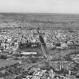
[General description] Panoramic view looking south down King William Street towards the parklands, suburbs and distant hills. In the foreground on the left is Government House. [On back of photograph] 'Aerial view of Adelaide / 1928'.
Adelaide View
Aerial view of Adelaide looking south from North Adelaide. The South Parklands provide an obvious barrier between the city and the southern suburbs.

Adelaide View
Aerial view of Adelaide looking south-west. In the fore ground to the left is Government House, looking left is the Institute building of the State Library of South Australia, the South Australian Museum and Adelaide University. The Army Barracks on the Parade Ground are just out of the photograph. Kintore Avenue seems to peter out near the Teachers College buildings. There is an empty block next to the Adelaide Club on North Terrace.

Adelaide View
Aerial view of Adelaide looking north east. This is a panorama view which connects with B 28355. For similar views see also 'Christmas supplement to the Adelaide Chronicle', Saturday 21 December 1907, page 7.

Port Adelaide
Aerial view of Port Adelaide (on the left), Birkenhead (on the right) and Semaphore (in the distance).