Geological formations in South Australia [B 69399] • Photograph


Perm-Carb. Till Hallett's Cove
Close-up of rock formation shown in B 69399/29.

Perm-Carb. Till, Myponga
Pages Creek, and surrounding vegetation, Myponga.

Perm-Carb. Till, Myponga
Close-up of rocks in bank of Pages Creek, Myponga.

Permo-Carboniferous tillite rock
Outcrop of Permo-Carboniferous tillite rock, Mount Breckan.

Prem-Carb. Till, Mount Breckan
Rock formation, Mount Breckan.

Perm-Carb. Till, Inman Valley
Geological formation, Inman Valley. The Inman Valley supplies the most striking evidence of Permo-Carboniferous glaciation in Australia.

Perm-Carb. Till, Inman Valley
Boulders in paddock, Inman Valley.

Perm-Carb. Till Inman Valley
Granite boulder, Inman Valley.

Perm-Carb. Till Inman Valley
Striated glacial pavement, Inman Valley.

Perm-Carb. Till Inman Valley
Granite boulders in bed of River Inman.

Perm-Carb. Till Inman Valley
Geological formation in bank of river bed, Inman Valley.

Perm-Carb. Till Inman Valley
Rocky outcrops with bag leaning up against rock to show scale of formation.

Perm-Carb. Till Inman Valley
Rock formation, probably granite, in side of Inman River valley.

Perm-Carb. Till Cape Jervis
Large erratics(?) on slopes of beach at Cape Jervis.

Perm-Carb. Till Cape Jervis
Rocks in cliff face, Cape Jervis.

Mount Gambier
Crater lake, Mount Gambier, with Centenary Tower on top of Tower Hill.
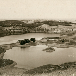
Mount Gambier
Crater Lakes, Mount Gambier.

Blue Lake
Close-up photograph of the pumping station with Blue Lake behind it.

Blue Lake, Mount Gambier
The Blue Lake, Mount Gambier.

Mount Schank
Close-up photograph of side of Mount Schank crater.

Mount Schank
Crater lake , Mount Schank, about seven miles from Mount Gambier.

Mount Burr
Rocky outcrop, Mount Burr.

Ewens Ponds ten acres
Ewens Ponds, east of Port MacDonnell.