Find • river torrens • Results 121 to 150 of 1,209


Flooded Torrens River at West Beach
Floodwaters in the Torrens River going over the spillway below the Seaview Road Bridge, 27 September 2016.

Flooded Torrens River at West Beach
Floodwaters in the Torrens River on the spillway below the Seaview Road Bridge, 27 September 2016.

Torrens River
View of the Torrens River looking northwest towards St. Peter's Cathedral. There is scaffolding up at the Womens and Children's Hospital [See B 77192/593 for a similar view].

Torrens River
View of the Torrens River and Lake, looking east, possibly from the Weir.

Torrens River parklands
View of the Torrens River and surrounding parklands looking east from the City Bridge. Caption on back of photograph: 'Scene from gardens beside City Bridge, looking East. A.E. on the path'.

River Torrens
Torrens River in the Gorge 12 miles from Adelaide.

River Torrens, Underdale
Improvements to Torrens river bed at Underdale before widening by E. and W. S. Department. The photograph shows a dry river bed spanned by an old arched gum tree trunk

River Torrens, south bank
Boat-houses on the south bank of the Torrens River a few yards east of the City Bridge. September 18, 1934. Torrens Rowing Club premises erected in 1932-33 (compare with B 6221) are about 40 yards east of the City Bridge. The water level is low and many rowing boats can be seen moored on the banks of the Torrens Lake.

Torrens Lake
Torrens Lake (from north bank of River Torrens, looking toward rear of Exhibition Building). The first Exhibition Building was completed for the South Australian Agricultural and Horticultural Show of 1860. This is the building in the photograph with the paired pilasters and wide verandahs. The domed Jubilee Exhibition Building and Grounds dominate the scene. A man is sitting in the foreground on the bank of the River Torrens

Torrens Weir in flood
Torrens Weir in flood.

View of the Torrens River
View looking east from King William Road bridge, showing a number of rowing skulls and teams, with spectators on the bank and pontoon.

Torrens Lake
View of Torrens Lake and banks of the River Torrens, with three people in a rowing boat. Adelaide City skyline visible in the background. View is taken from the northern bank of the River Torrens, west of the Morphett Street bridge.
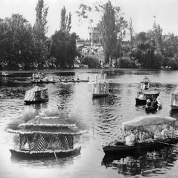
Decorated boats at the Henley on Torrens regatta, Adelaide
Close view of rowing boats decorated to represent swans and summer houses sailing on the Torrens River during the Henley on Torrens regatta, Adelaide.

River in the Adelaide Hills
Stereoscopic view of a stream flowing through a hilly area. This is identified on the back of the photo as 'The Weir River Torrens' but is more likely to be a weir in the upper reaches of the Torrens River (possibly near Kangaroo Creek Reservoir).

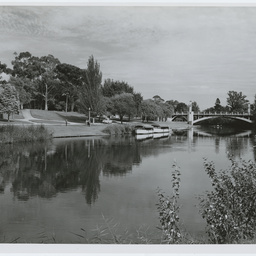
Torrens River and Adelaide Riverbank
View of the River Torrens and Adelaide Riverbank at night, prior to the construction of the footbridge.

River Torrens Floodwater
Torrens River floodwaters running for the first time into the sea by way of a recently completed outlet at Henley South. The flood prone area at Henley South was relieved by the opening of the River Torrens outlet in 1937. Prior to this winter rains caused havoc to the train and tram networks in the area.

Torrens Railway bridge
Railway bridge over River Torrens before 1900. Photograph shows workers standing on the new bridge looking down on the muddy puddles of the river which is strewn with debris. The river banks are very steep.

River Torrens flowing through Paradise
PARADISE: Part of the Torrens River flowing through Paradise, the subject of a painting by Henry James Johnstone.

River Torrens, Adelaide
View along the Torrens River looking south-east, with Elder Conservatorium (right) and the Exhibition Building in the background.

River Torrens from Adelaide Zoo
A view of the River Torrens taken from outside of the Adelaide Zoo looking across to grassy park land along War Memorial Drive. The dome of the Exhibition Building, since demolished, is visible on the horizon. The opposite river bank is steep. The caption reads, 'Torrens Lake, Adelaide' (sic).

Torrens River
Photograph of the River Torrens showing the willows and other vegetation along the bank. Copy made from negative from lantern slide.

Torrens River
Photograph of the River Torrens showing the willows and other vegetation along the banks. The spires of St. Peter's Cathedral are just visible in the background. Copy made from negative from lantern slide.

Bridge over the River Torrens
View of the original Adelaide City bridge over the Torrens River on King William Street. The bridge was built in 1855 and replaced in 1877.

Flooded tents along the Torrens
[General description] A weeping willow frames the scene of a row of makeshift tents (cobbled together with a variety of materials) being engulfed by the swollen river. [On back of photograph] 'River Torrens in flood, September 3, 1931 / showing the huts occupied by the unemployed / behind the zoological gardens / Reproduced in the 'Chronicle' for September 10, 1931' (Another hand) 'The removal of all huts etc. occupied by the unemployed was ordered by the City Council to take place early in 1938'.

River Torrens (Karra wirra-parri)
River Torrens also known by its Kaurna name Karra wirra-parri, meaning river of the Red Gum forest. "Colourful gardens and the University Bridge across the Torrens."
River Torrens (Karra wirra-parri) near the City Bridge
River Torrens also known by its Kaurna name Karra wirra-parri, meaning river of the Red Gum forest. "Scene on the Torrens near the Adelaide City Bridge".

River Torrens rowing regatta
Rowing regatta on the Torrens Lake. Another copy is in Sweet Collection folder 3.
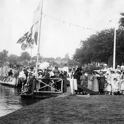
Spectators at the Henley on Torrens Regatta
Spectators crowded onto a landing jetty and along the banks of the River Torrens during the annual regatta held on 'Henley on Torrens' day; a feature were floral decorated boats which can be seen nearby.
![Western Sources of the Torrens [cartographic material]](https://slsa-collections.s3.amazonaws.com/e9/42/2bdc-d8f3-54a4-aa24-aab5cc8fbfd2.jpg)
Western Sources of the Torrens [cartographic material]
'Sketch of sections in the Special Survey of the Western Sources of the Torrens [Hundred of Talunga] purchased 31 August 1849 to secure both sides of the stream' (River Torrens) as per title on verso. Annotated to show purchases of Sections 6111, 6113, 6349 and 6349 by the South Australian Company, shown in green with other sections already owned by the Company. These sections are located south west of Gumeracha, near Cudlee Creek and south east of Forreston. Ink with watercolour wash on paper, ink notation. No scale given. Stamped with date 12.2.[18]50 and handwritten signature 'A.W.' in right hand bottom corner. (Original mounted on same sheet as maps 16-18).
![Portion of plan of Eastern Sources of the Torrens previously forwarded to the London Office [cartographic material]](https://slsa-collections.s3.amazonaws.com/5f/a5/380e-7976-5a7b-b79d-391e8feec972.jpg)
Portion of plan of Eastern Sources of the Torrens previously forwarded to the London Office [cartographic material]
Plan of Eastern Sources of the Torrens, showing land purchased 1 December 1853 on sections 7021-7023, 7025 and 7028, shown in green, in the vicinity of Mount Pleasant. Three other sections, 6611, 6624 and 6625, north east of Birdwood, are also shown in green. All the sections are located on the north side of the River Torrens. Ink with watercolour on paper, ink notation. No scale given. Stamped with date 17.2.[18]54; signature 'E.R.S.' in left hand bottom corner.