Find • river torrens • Results 1,201 to 1,209 of 1,209

![Plan of the intended New Port, Adelaide, South Australia [cartographic material]](https://slsa-collections.s3.amazonaws.com/10/1d/8c0e-59cb-58c4-8bec-ccd2b00c1a14.jpg)
Plan of the intended New Port, Adelaide, South Australia [cartographic material]
Similar to C 1074 but earlier, fewer roads, text on right hand side of map rather than left, information slightly different. Covers the area from Torrens Island to Albert Town, shows sections with owner's names and government and public reserves. Soundings given for the river and tidal information is included. Published by Light, Finniss & Co.
![Plan of the township of Gilleston [cartographic material] /
by C.B. Young, Surveyor](https://slsa-collections.s3.amazonaws.com/e6/ce/e792-fd57-57e9-a05c-9168c7d72c41.jpg)
Plan of the township of Gilleston [cartographic material] / by C.B. Young, Surveyor
Map of land to be sold at auction on 26 April 1858 by R.B. Colley. Area is adjacent to Balhannah and lies between the Onkaparinga River and Mt. Torrens Road (which leads to Adelaide). Streets named, lot numbers and measurements shown. Penman & Galbraith, lithographer. Some annotations in ink.
![South Australia, Adelaide [cartographic material] :
no. 810, zone 6, sheet south I54M ; IV SE & SW /
prepared by Australian Section, Imperial General Staff](https://slsa-collections.s3.amazonaws.com/ca/50/b081-505f-5be6-bb79-d350bbc92b13.jpg)
South Australia, Adelaide [cartographic material] : no. 810, zone 6, sheet south I54M ; IV SE & SW / prepared by Australian Section, Imperial General Staff
Topographic map of Adelaide region, from Salisbury to Crafers and from Semaphore to Mt Torrens, with some cadastral detail. Includes roads, railways, suburban villages, rivers, creeks, vegetation, farms and place names. Relief shown by contours and spot heights. Elevation in feet. Surveyed 1937, published August 1939.

Brewery Christmas Display
Brewery Christmas Display, Thebarton.

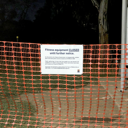
Closed Park
Closed Park Gym / exercise equipment along the walkway at the Ascot Avenue Walkerville entrance to the Torrens River linear park was closed off to prevent the spread of Covid-19.
Closed Park
Park gym / exercise equipment along the walkway at the Ascot Avenue Walkerville entrance to the Torrens River linear park was closed off to prevent the spread of Covid-19.

Series 070: Osborne Power Station
Aerial photographs of Osborne Power Station on the Port River. Some views include Torrens Island and Outer Harbor, and nearby buildings and structures including a gasometer.

Series 090: Aerial photographs of the Port Adelaide Wastewater Treatment Plant and Finsbury Park
Aerial views of Port Adelaide Wastewater Treatment Plant and Finsbury Park (later part of Pennington), showing industrial buildings after World War II.

Series 132a: Aerial photographs of Victor Harbor, Port Noarlunga and Klemzig
Aerial photographs around South Australia, including views near Victor Harbor, at Port Noarlunga, and a farm near the Torrens River at Klemzig.