Find • river torrens • Results 1,171 to 1,200 of 1,209


An interstate university rowing team
An interstate university rowing team practising on the Torrens River, Adelaide, South Australia.

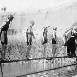
Male contestant in a swimming race
A male contestant photographed in the Torrens river during the 'swim through Adelaide' swimming competition; name not known.

Swim through Adelaide race
Competitors swimming in the Swim through Adelaide race watched by a large crowd of spectators on the banks of the Torrens River.

Women's rowing team
Women, with a male cox, rowing on the Torrens River, Adelaide, South Australia.
A swimming race at Gilberton
Competitors lined up for the start of a women's swimming race held in the Torrens River at the Gilberton Swimming Club, South Australia.

Swimming carnival at Gilberton
Spectators watching events from the banks of the Torrens river during a carnival at the Gilberton Swimming Club, South Australia.

Swimming carnival at Gilberton
Spectators sitting on the banks of the Torrens river, with some boys and young men dipping their bare feet in the water during a swimming competition held at Gilberton Swimming Club, South Australia.

Hackney Bridge
Distant view of the bridge over the Torrens River at Hackney, South Australia; the Hackney Hotel can be seen on the right.

The winner of a swimming race
The winning competitor in the 'Swim through Adelaide' swimming race, standing with a group of spectators on the banks of the Torrens River, Adelaide, South Australia.

Swimming gala at Gilberton
Spectators attending a swimming gala held in the Torrens River at Gilberton, South Australia.
![Map shewing the line of the intended Adelaide City and Port Adelaide Railway [cartographic material]](https://slsa-collections.s3.amazonaws.com/0e/7d/8117-8267-59e5-aadf-0f0ea288e9a4.jpg)
Map shewing the line of the intended Adelaide City and Port Adelaide Railway [cartographic material]
Map showing the route of the proposed railway line from Adelaide to Port Adelaide in red ink. Also shows suburban areas and Lefevre Peninsula section numbers, Torrens Island and reaches of the Port River. Drawn by H. Higginson, Lefevre Terrace, North Adelaide. Lithograph with blue watercolour wash on paper.(Extreme bottom corners of map missing.) Scale 2 inches to 1 mile.
![Plan of the intended new port, Adelaide, South Australia [cartographic material] /
by J. Dean](https://slsa-collections.s3.amazonaws.com/de/b9/7b5c-b5f6-598b-904d-34a27cd86101.jpg)
Plan of the intended new port, Adelaide, South Australia [cartographic material] / by J. Dean
Plan of the new port at Port Adelaide as designed by His Excellency Col. G. Gawler, K.H., divided into sections of 80 and 134 acres. Area of plan extends from Torrens Island to part of Albert Town and shows soundings in feet along reaches of the Port River. Sections numbers of land affected by the new development shown, with route of proposed road to the Northern Mines. Outside map area is an explanation of details shown in the plan, and names of proprietors of land sections in new development (S.A. Company, J.A. Smith, J. Morphett & O. Gilles, John Ellis, T.B. Strangways). Issued as supplement to the "South Australian" newspaper 2 January 1846. Lithographed by J. Dean, Adelaide. Scale 2 inches to 1 mile. (Original on same sheet as map 11).

Photographs around Adelaide and suburbs
A selection from travel photographs taken by amateur photographer G.R. Oliver. Identified as being from 'Brighton, Glenelg, Adelaide'.
South Australian scenes and activities 7
Part of a collection of slides taken by amateur photographer Elva Heinemann of South Australian scenes and activities, featuring Port Lincoln, Eyre Peninsula, the Adelaide Zoo and Torrens River near the Zoo, 1965. See 'contents' for details of individual images.

South Australian scenes and activities 10
Part of a collection of slides taken by amateur photographer Elva Heinemann of South Australian scenes and activities, featuring Adelaide and the Queen's visit. See 'contents' for details of individual images.

Market garden at Klemzig
Copy of a photograph showing a view of the market garden property owned by Charles and Ethel Heading at Klemzig. This photo was taken from the old home, looking towards the Torrens River over fruit trees.
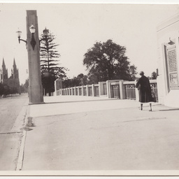
King William Road, Adelaide
A woman walking on the pavement of King William Road, towards North Adelaide, on the eastern side of the City Bridge.

Murals arranged by project
The series consists of photographs, negatives, transparencies, correspondence, drawings, paintings, pamphlets and a wooden model which relate to murals created by J S Ostoja-Kotkowski. These include projects for hotels, the Adelaide Airport, B.P. House in Adelaide, B.P. House in Melbourne, Ciba-Geigy building in Preston Victoria, Earth Sciences building University of Melbourne, Montreal Expo 67, Nauru House Melbourne, National Mutual building Adelaide, Polish Church, Polish House, Solaris, South Australian Institute of Technology, State Educational Centre, Unley shopping centre and the Weir restaurant in Adelaide. Chronology:. 1955 Milford House North Adelaide. 1957 Pier Hotel Glenelg; Tasman Hotel Port Lincoln. 1960 Taboo Peel St Adelaide. 1961 Weir restaurant Adelaide. 1962 Office mural; National Mutual building Adelaide; vitreous enamel mural Kym Bonython gallery(?). 1964 Vitreous enamel mural Melbourne. 1965 BP House Adelaide; BP House Melbourne; Dollar Club Adelaide. 1966 Unley shopping centre. 1967 Montreal expo. 1968 Chanteclaire; school seminary refectory North Adelaide. c1960s M Hobbs vitreous enamel mural; Hotel Elizabeth Melbourne; Hotel Eyrie Whyalla; mosaic mural Adelaide; restaurant mural. 1970 Adelaide airport s'pacescape'; MLC building Melbourne; ANZ Bank Adelaide. 1971 Ciba Geigy building Preston Victoria. 1973 Polish House Adelaide. 1975 Earth Sciences building University of Melbourne. 1976 Nauru House Melbourne; Kooroora Hotel. 1977 South Australian Institute of Technology; State Educational Centre Adelaide. 1978 Op mural Stirling hardware; op mural chemist shop. 1980 Perspex mural Kay. 1981 Telecom Australia. 1986 Sheik's restaurant Adelaide; Solaris Sydney. 1987 Polish church mosaic Adelaide. 1988 Brisbane expo Solaris Mk2. No date: Eta food factory Adelaide; Perth tapestry project; Shamern's(?); Twelve Apostles and various unidentified murals.

City bridge, Adelaide
City bridge, Adelaide. The bridge is reflected in the water.

The brewery Easter display
The Easter display on the banks of the Torrens River by the brewery at Hindmarsh, the main feature being a giant egg filled with a family of chickens.

City Bridge
A view of the Adelaide City Bridge and Torrens Lake with two children playing on the edge of the river bank.

Brewery Christmas Light
View of the Brewery Christmas Lights during the day, showing the Water Wheel and other scenes.

Christmas Brewery Lights display
Christmas Brewery Lights display at night.

Christmas Brewery Lights display
Christmas Brewery Lights display at night.
![Chart of Port Adelaide, South Australia [cartographic material] /
drawn by F.H. Burslem](https://slsa-collections.s3.amazonaws.com/52/50/9440-7623-5b2f-963a-0b2895e0d06f.jpg)
Chart of Port Adelaide, South Australia [cartographic material] / drawn by F.H. Burslem
This chart was compiled from Colonel Light's survey with soundings by S. Hamilton, drawn by F.H. Burslem of the Survey Department and engraved by W. Moffitt, Sydney. Shows coast, river with soundings, and Torrens Island. Includes natural features. Although dated 1839, map and detailed navigation notes on right hand edge date this version at 1840. Title of map at bottom right does not have its supporting kangaroos and emu figures as in map 120/2. Scale 2 inches to 1 mile. (On reverse side is printed the 1839 map without the text on left hand edge, another copy of map 120/2 in this series.) [Double sided map; previously C155 & C156].

Adelaide City Bridge construction
Construction work on the new Adelaide City Bridge, looking northwest towards Elder Park.
Photographs of Marjorie Andrew
Photographs selected from an album, showing holidays and work in South Australia and the Northern territory from 1937 to 1938. Comprising South Australian views and scenes: Holidays to Tumby Bay and the Eyre Peninsula, Barmera, Victor Harbor, a paddle steamer holiday on the Murray River, Point McLeay Mission Station (now Raukkan), portraits with family and friends, Henley-on-Torrens Regatta, and ships. Northern Territory views and scenes include: group portraits of friends and colleagues from the Allied Works Council in Alice Springs, including the A.W.C. hostels, Anzac Day celebrations in Alice Springs, holiday views of the McDonnell Ranges and surrounding locations and beaches near Darwin, and sites in Darwin, some showing military locations and the destruction after the bombing raid in 1942. Also includes some photographs of Australian troops and camps at the end of the Second World War, on the Indonesian island of Morotai. To view images, do an ARCHIVAL NUMBER search for PRG 1708/3.

Aerial photographs of the city of Salisbury : Dry Creek
Aerial views of Dry Creek in the city of Salisbury, South Australia, including views of salt pans, Torrens Island, Little Para River, and mangroves.
![Map of South Australia, showing the line of telegraph across the continent to the Northern Territory [cartographic material] /
signed Alfred Everard Lucy](https://slsa-collections.s3.amazonaws.com/25/da/d6c4-9229-5e20-840f-4399022eb114.jpg)
Map of South Australia, showing the line of telegraph across the continent to the Northern Territory [cartographic material] / signed Alfred Everard Lucy
Shows telegraph line from Port Augusta to Port Darwin - part completed, part in progress; Lake Torrens and Peake Station; James, Devenport, Stuart's and Strangways Ranges; Arthur's Hill, Mount Denison and Sturt's Plain; Roper and Adelaide Rivers; Point Patterson. Ink.
![Perpetual lease blocks under the Closer Settlement Act, Paracombe [cartographic material] /
Surveyor General's Office, Adelaide](https://slsa-collections.s3.amazonaws.com/3f/14/cd41-7503-5c95-9c9e-06304f6e9377.jpg)
Perpetual lease blocks under the Closer Settlement Act, Paracombe [cartographic material] / Surveyor General's Office, Adelaide
Details include showing location of Hundreds of Yatala and Para Wirra, section numbers and size, notes on natural features, location of established buildings, the Torrens River and the towns of Inglewood and Paracombe. Right hand of map has detailed description of the leases including area, annual rent, value and description of improvements. A. Vaughan, Photolithographer.