Find • darwin • Results 451 to 480 of 1,329


Shoreline at Port Darwin
Port Darwin from the sea showing a rocky outcrop and navigation marker.


Government Cottage at Port Darwin
Looking down on the roof of the Government Cottage known as 'The Camp' at Port Darwin. and to the beach beyond, 1905.


Jetty at Port Darwin
Identified by Gee as the 'old Gulnare Jetty' and adjacent to other photos in the Port Darwin region it seems likely this refers to both the ship 'Gulnare' and the jetty.


Jetty at Port Darwin
Darwin jetty with ship at anchor, 1905.


Darwin jetty
Darwin Jetty, 1905.


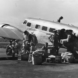
Father Christmas at an airport in Darwin
A man dressed as Father Christmas stands next to a small plane. He is holding some large bags and there are several small children with him. Two men are sorting through boxes and parcels on the ground. Father Christmas has travelled to Darwin from the Magic Cave in John Martin's department store in Adelaide.


Father Christmas at an airport in Darwin
A man dressed as Father Christmas stands next to a small plane. He is holding some large bags and there are several small children with him. Several men are sorting through boxes and parcels on the ground. Father Christmas has travelled to Darwin from the Magic Cave in John Martin's department store in Adelaide.


Father Christmas arrives in Darwin
A man dressed as Father Christmas is surrounded by a large group of children in Darwin. He has just arrived by plane from the Magic Cave in John Martin's department store in Adelaide.


Father Christmas arrives by plane in Darwin
A man dressed as Father Christmas stands next to a small plane in Darwin. He is holding a large bag and there are two small children next to him. Parcels and boxes are scattered on the ground and some of the parcels have John Martin & Co Ltd stamped on the side. The plane has Guinea Airways Ltd written on the side. Father Christmas has travelled from the Magic Cave in John Martin's department store in Adelaide.

![General plan showing ... Port Darwin, Northern Territory of South Australia [cartographic material]](https://slsa-collections.s3.amazonaws.com/7b/05/ca38-baf6-571c-ba86-509f67932260.jpg)
General plan showing ... Port Darwin, Northern Territory of South Australia [cartographic material]
Surveyed during 1869 by Woods, McLachlan, Smith, Mitchell, Harvey, McMinn, also Thomas, Knuckey, King, Daly and Mills under the direction of the Surveyor-General. Details include towns, reserves, roads and sectional lands at and in the vicinity of Port Darwin. Gives section numbers, major natural features named. Also some notes on natural features. Frazer S. Crawford, Photolithographer, Surveyor-General's Office, Adelaide.

![Country in the vicinity of Port Darwin [cartographic material] /
signed G.W. Goyder](https://slsa-collections.s3.amazonaws.com/f9/a0/9bcf-6b7b-51bf-8883-ed754ae02093.jpg)
Country in the vicinity of Port Darwin [cartographic material] / signed G.W. Goyder
Describes natural features from Fred's Pass to Port Darwin examined during the month of February 1869. Route taken shown in coloured ink. Copy made by Bessie Threadgill of original in Home and Territories Office, Melbourne.

![Country in the vicinity of Port Darwin showing sections surveyed [cartographic material] /
signed G.W. Goyder](https://slsa-collections.s3.amazonaws.com/8f/81/db5a-1ff2-5608-b121-69656f7963e3.jpg)
Country in the vicinity of Port Darwin showing sections surveyed [cartographic material] / signed G.W. Goyder
Detailed description of natural features between Bynoc Harbour and Adelaide River. Includes section numbers at various locations including Port Darwin. Route taken shown in coloured ink. Copy made by Bessie Threadgill of original in Home and Territories Office, Melbourne.


Keith Smith at memorial in Darwin
Sir Keith Smith at Sir Ross Smith's memorial in Fannie Bay, Darwin, Northern Territory.


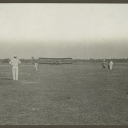
Vickers Vimy and crew arriving in Darwin
Spectators gathered at Fannie Bay airfield in Darwin to view the arrival of the Vickers Vimy and crew, 10 December 1919.


Vickers Vimy arriving in Darwin
Spectators gathered at Fannie Bay airfield in Darwin to view the arrival of the Vickers Vimy and crew, 10 December 1919.


Vickers Vimy and crew arriving in Darwin
Spectators gathered at Fannie Bay airfield in Darwin to view the arrival of the Vickers Vimy and crew, 10 December 1919.


Telegraph Station, Port Darwin
'The telegraph station at Port Darwin during the construction of the line'. Written on reverse: Telecom, 22.


Harold Theodore Darwin
Harold Darwin in a bush setting.


Harold Darwin alongside his library on trailer wheels.
Harold Darwin examines a book from his mobile library.


Harold Shepherdson at the Darwin mission house
"H.U.S. in Darwin 1927". Harold Shepherdson at the Mission House.


Children from the Croker Island Methodist Mission visiting Darwin
"A party of part Aboriginals in Darwin, 1930s". The Misison for "Part Aborignals" was Croker Island.


Lighthouse at East Point, Darwin, Northern Territory
"Think it's the lighthouse at East Point, Darwin"


Horse and wagon on the road to Darwin
"The horse and trap used for visiting Darwin"


Point Charles lighthouse at Darwin Harbour
"The Lighthouse at entrance to Darwin Harbour". Possibly Point Charles llighthouse.


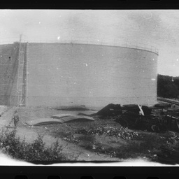
Fuel tank at Darwin Harbour
"The fuel tank at Darwin Harbour". These fuel oil storage tanks at Stokes Hill were bombed on 19 February 1942 in the first Japanese air raid. Following this, oil storage tanks were secured in underground tunnels.


Fuel tank at Darwin Harbour
"The fuel tank at Darwin Harbour". These fuel oil storage tanks at Stokes Hill were bombed on 19 February 1942 in the first Japanese air raid. Following this, oil storage tanks were secured in underground tunnels.


Ship 'Malabar' at Darwin wharf
"? Malabar at Darwin wharf c1928".


Baby Noel Kentish in Darwin
"Noel Kentish, Darwin c1938".


East Point Lighthouse, Darwin
"East Point lighthouse, Darwin 1930s".


Photograph albums belonging to Hermann and Hilda Heinrich
Records comprise photographs taken from three photograph albums belonging to Hermann and Hilda Heinrich. Captions found on the photographs have been noted in quotation marks. Some captions have been provided by Ilona Oppenheim. Photographs show activities in and around Hermannsburg Mission, people of the Mission, Alice Springs, Darwin, Henbury Station, Gosse Ranges, Palm Valley and other places in Central Australia.
