Find • adelaide aerial • Results 361 to 390 of 653

Aerial photographs of the city of Salisbury : Parafield Gardens
Aerial views of Parafield Gardens in the city of Salisbury, South Australia, including views of: Baltimore Reserve, Creaser Park, Angkor Hall, Parafield Gardens High School, Holy Family Catholic School, industrial buildings, The Pines Primary School, Andrew Smith Drive Oval, Salisbury Villa Football Club, Reg Groth Reserve, Thomas More College, Parafield Airport, Salisbury Downs Primary School, AGH Cox Reserve, salt pans and views of Torrens Island and Outer Harbor in the distance.

Aerial photographs of the city of Salisbury : Green Fields
Aerial views of Green Fields in the city of Salisbury, South Australia, including views of warehouses, factories and industrial buildings.

Aerial photographs of the city of Salisbury : Salisbury East
Aerial views of Salisbury East in the city of Salisbury, South Australia, including views looking east towards Burton and Parafield Gardens, and Tyndale Christian School, Salisbury East High School, with views of Parafield Airport and Boral Quarries in the distance.

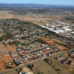
Aerial photograph of the city of Salisbury : Brahma Lodge
Aerial view of Brahma Lodge in the city of Salisbury, South Australia, including view of Brahma Lodge Oval, Brahma Lodge Primary School, and Parafield Airport in the distance.

Aerial photographs of the city of Salisbury : Parafield
Aerial views of Parafield in the city of Salisbury, South Australia, including views of Parafield Airport.

Aerial photographs of the city of Salisbury : Salisbury South
Aerial views of Salisbury South in the city of Salisbury, South Australia, including views of industrial buildings, warehouses, factories and surrounding areas.

Aerial photographs of the city of Salisbury : Salisbury Downs
Aerial views of Salisbury Downs in the city of Salisbury, South Australia, looking south over Parafield Gardens including views of the Parafield Gardens Swim School, Salisbury Villa Football Club, Parafield Gardens High School, and Hollywood Plaza, Salisbury Downs Primary School, and the Salisbury West Oval.

Aerial photographs of the city of Salisbury : Salisbury Plain
Aerial views of Salisbury Plain in the city of Salisbury, South Australia, including views of factories, warehouses, industrial buildings, Tyndale Christian School, and Salisbury East High School.

Aerial photographs of the city of Salisbury : Paralowie
Aerial views of Paralowie in the city of Salisbury, South Australia, including views of Settlers Farm Primary School, General Drive Reserve, Estia Aged Care, Springbank Plaza, residential areas, Heyne's Nursery, Kaurna Park Wetlands, and Bolivar Sewage Treatment Works.

Aerial photographs of the city of Salisbury : Bolivar
Aerial views of Bolivar in the city of Salisbury, South Australia, including views of salt pans, St Kilda, fields and gardens, Bolivar Sewage Treatment Works, Southern Go-Kart Club, Bolivar Raceway, with Torrens Island and Outer Harbor in the distance.

Aerial photographs of the city of Salisbury : Salisbury North
Aerial views of Salisbury North in the city of Salisbury, South Australia, including views of the Salisbury North West Primary School, Paralowie School, Adams Oval, Salisbury Soccer Club, Cycle Speedway, and the Salisbury North Sports oval.

Aerial photographs of the city of Salisbury
Aerial views of Salisbury, South Australia, looking South, including views of the Parabanks shopping centre, Salisbury Oval, swimming centre, and Little Para Golf Course.

Aerial photographs of the city of Salisbury : Burton
Aerial views of Burton in the city of Salisbury, South Australia, including views of shopping centres, industrial buildings, factories, and warehouses, salt pans, residential areas, surrounding fields, Burton Primary School, the Springbank Plaza shopping centre under construction, and the Steve Jarvis Park and Salisbury United FC under construction.

Aerial photographs of the city of Tea Tree Gully : Highbury
Aerial views of Highbury in the city of Tea Tree Gully, South Australia, including views of the Hope Valley Reservoir, shopping centres, Athelstone Football Club, Paradise Primary School, Highbury Hotel, Turramurra Recreation Centre, Hope Valley Football Club, Highbury Primary School, Highbury Aqueduct Reserve, and River Torrens Linear Reserve.

Aerial photographs of the city of Tea Tree Gully : Hope Valley
Aerial views of Hope Valley in the city of Tea Tree Gully, South Australia, including views of Hope Valley Reservoir, Estia aged care, industrial warehouses and factories, Lutheran Homes aged care, Modbury High School, Hope Valley football, tennis and netball clubs, Highbury Primary School, and Highbury Hotel.

Aerial photographs of the city of Tea Tree Gully : Vista
Aerial views of from Vista in the city of Tea Tree Gully, South Australia, including views looking over Highbury High School, Highbury Hotel, River Torrens Linear Reserve, and views of Athelstone.

Aerial photographs of the city of Tea Tree Gully : St Agnes
Aerial views of St Agnes in the city of Tea Tree Gully, South Australia, including views of St Agnes Primary School, Tea Tree Gully BMX Club and race track, industrial buildings, warehouses and factories, Hope Valley Football Club and oval, Lutheran Homes Retirement Village, and Modbury High School.

Aerial photographs of the city of Tea Tree Gully : Modbury
Aerial views of Modbury in the city of Tea Tree Gully, South Australia, including views of Westfield Tea Tree Plaza, Civic Park, TAFE SA, Modbury Hospital, Modbury Primary School, Modbury High School, Hope Valley Reservoir, Modbury Triangle Shopping Centre, and the City of Tea Tree Gully Library.

Aerial photographs of the city of Tea Tree Gully : Ridgehaven
Aerial views of Ridgehaven in the city of Tea Tree Gully, South Australia, including views of Pertaringa Oval, Bulkana Oval, Banksia Park International High School, Ridgehaven Primary School, Ashley Avenue Dog Park, Anstey Hill Recreation Park, and Westfield Tea Tree Plaza shopping centre.

Aerial photographs of the city of Tea Tree Gully : Modbury North
Aerial views of Modbury North in the city of Tea Tree Gully, South Australia, including views of Burragah Reserve, shopping centre, Baptist Church, Waterworld Acquatic Centre, Smith Partners Stadium, Modbury Primary School, Civic Park, soccer field, and the Heights School and Observatory.

Aerial photographs of the city of Tea Tree Gully : Banksia Park
Aerial views of Banksia Park in the city of Tea Tree Gully, South Australia, including views of quarries, Tea Tree Gully Golf Course, Tea Tree Gully Athletics Centre, Pertaringa Oval, orchards and vineyards, Banksia Park International High School, and Banksia Park Primary School.

Aerial photographs of the city of Tea Tree Gully : Modbury Heights
Aerial views of Modbury Heights in the city of Tea Tree Gully, South Australia, including views of The Heights school and observatory, local parks and reserves, Richardson Reserve, Golden Grove Lutheran Primary School, and the Modbury Heights shopping centre.

Aerial photographs of the city of Tea Tree Gully : Fairview Park
Aerial views of Fairview Park in the city of Tea Tree Gully, South Australia, including views of Tea Tree Gully Golf Course, Tea Tree Gully Athletics Centre, Pertaringa Oval, Banksia Park primary school and high school, Hope Valley Reservoir, and Fairview Green shopping centre.

Aerial photographs of the city of Tea Tree Gully : Wynn Vale
Aerial view of Wynn Vale in the city of Tea Tree Gully, South Australia, including views of Modbury Vista Soccer Club, Golden Grove Lutheran Primary School, Kings Baptist Grammar School, Boral Concrete, and Golden Grove High School.

Aerial photographs of the city of Tea Tree Gully : Golden Grove
Aerial views of Golden Grove in the city of Tea Tree Gully, South Australia, including views of industrial buildings, quarries, Estia aged care, Little Para Reservoir, Harper's Field, Greenwith Oval, Pedare Christian College, Gleeson College, Golden Grove High School, Golden Grove Recreation Centre, The Grove Shopping Centre, Boral Concrete, Golden Grove Lutheran Primary School, and Kings Baptist Grammar School.

Aerial photographs of the city of Tea Tree Gully : Greenwith
Aerial view of Greenwith in the city of Tea Tree Gully, South Australia, looking west from Greenwith, over Salisbury Heights, including veiw of Immanuel Conservation Reserve and Castieau Reserve.

Aerial photographs of the city of Salisbury : Ingle Farm
Aerial views of Ingle Farm in the city of Salisbury, South Australia, including views of RM Williams Drive Reserve, Walkley Heights, Ingle Farm East Primary School, and Golding Oval.

Aerial photographs of the city of Salisbury : Para Vista
Aerial views of Para Vista in the city of Salisbury, South Australia, including views of Ingle Farm East Primary School, Valley View Secondary School, Golding Oval, Para Vista Primary School, Ingle Farm shopping centre, Helping Hand nursing home, Kentish Green, and Good Shepherd Lutheran School.

Aerial photographs of the city of Salisbury : Cavan
Aerial views of Cavan in the city of Salisbury, South Australia, including views of industrial factories, warehouses and buildings, and railway lines.

Aerial photographs of the city of Victor Harbor : Waitpinga
Aerial views of Waitpinga near the city of Victor Harbor, South Australia, including views of King Head and West Island, a quarry, and Encounter Bay and Victor Harbor in the distance, with surround fields and hills in the foreground.