Series 019: Aerial views of Port Adelaide and Outer Harbor [BRG 397/2/19] • Photograph

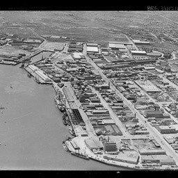
Item 01: Aerial view of Port Adelaide, looking east.
View along waterfront at Port Adelaide, with one ship and many smaller vessels berthed in the river. Buildings along North Parade, Nile Street and St Vincent Street can be seen clearly. Port Adelaide Railway Station and railyards are visible in the distance.

Item 02: Aerial view of Port Adelaide, looking north.
View of shipping along the Port River.

Item 03: Shed No. 4 at Outer Harbor.
Aerial view of ship alongside shed No. 4.

Item 04: Shipping at Outer Harbor, looking south west.
Aerial view of four ships berthed at Outer Harbor.

Item 05: Birkenhead Bridge under construction.
Aerial view of the early stages of construction work on the Birkenhead Bridge in the Port River.

Item 06: Aerial view of Port Adelaide, looking north.
View across Port Adelaide towards Torrens Island and Garden Island.

Item 07: Boat at sea.
Aerial view of a small boat with several men aboard.

Item 08: Boat at sea.
Aerial view of boat at sea.

Item 09: Aerial view of Port River.
Aerial view of shipping in Port River, looking south from Wharf 25.

Item 10: Port Adelaide from the air.
Aerial view of Port Adelaide, looking west towards the ocean.

Item 11: Aerial view of Port Adelaide.
View across the industrial buildings on the east bank of the Port River, looking south west towards the ocean.