Find • west adelaide • Results 2,821 to 2,850 of 3,162


Unidentified soldier
Quarter-plate glass negative of an unidentified soldier wearing World War One military uniform including knee-high boots and a slouch hat with the brim worn down. He has a braid around one shoulder and is holding a cane in his hands. He is standing in a yard in front of a wooden fence.

Two unidentified Australian soldiers
Half-plate glass negative of two unidentified Australian soldiers wearing World War One military uniforms including knee-high boots, belts and bandoliers. The soldier standing has a peaked cap and the seated soldier is wearing a slouch hat. They are posed in front of a background of a woodland path.

Unidentified Australian soldier
Half-plate glass negative portrait of an unidentified Australian soldier wearing a greatcoat and slouch hat with a sprig of wattle in the band, standing outside with a building in the background.
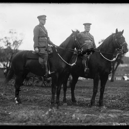
Two mounted officers
Half-plate glass negative of two mounted officers in World War One military uniform in a field with tents and wagons in the background. Some of the emulsion in the centre of the glass plate has worn away. The officer on the right is believed to be Lt-Col. F.J.D Darvall (see 'The Chronicle', Saturday 11 August 1928, page 23 for obituary).

Mounted Light Horse regiment
Half-plate glass negative of an unidentified regiment of Light Horsemen wearing World War One military uniforms including slouch hats, mounted on their horses and lined up in a row.

A. Bland
Half-plate glass negative of A. Bland wearing World War One military uniform including knee-high boots, belt, bandolier and slouch hat, with his rifle in one hand, and standing in front of a painted background of tents in an army camp with a tree in the foreground and hills in the background. Written on original paper envelope: 'A. Bland 3147'. Possibly Private Arthur Charles Bland.

Three Australian soldiers
Quarter-plate glass negative of three unidentified Australian soldiers wearing World War One military uniform including peaked caps, standing in front of a brick building. The soldier on the right has a lance-corporal's rank insignia on his right sleeve, and the soldier on the left has a corporal's rank insignia worn point uppermost.

Unidentified Australian soldier with two women
Quarter-plate glass negative of an unidentified Australian soldier wearing World War One military uniform including peaked cap, sitting outise between two young women, possibly nurses, who are wearing white long-sleeved blouses with long high-waisted skirts. There are trees in the background.

Unidentified soldier and friend
Quarter-plate glass negative of an unidentified soldier in World War One military uniform including peaked cap, standing next to a man wearing a suit, tie and hat. They are leaning against a fallen log and there are trees in the background.

Two soldiers with a gentleman
Quarter-plate glass negative of two unidentified soldiers wearing World War One military uniforms including belts, bandoliers and peaked caps, standing either side of an older gentleman wearing a suit and sitting in a chair. Possibly two brothers with their father. In the background is a wooden fence.

Unidentified soldier
Quarter-plate glass negative of an unidentified Australian soldier in World War One military uniform including knee-high boots, belt, bandolier, and slouch hat with the brim turned down, standing in front of a brick building with bars on the window.

Two unidentified soldiers
Quarter-plate glass negative of two unidentified Australian soldiers wearing World War One military uniforms. The seated soldier has rank insignia indicating a lance-corporal on his upper right sleeve, with overseas service chevrons below.

Cannon monument
Quarter-plate glass negative of a large cannon mounted on a stone base in a park with trees in the background.

Unidentified soldier
Quarter-plate glass negative of an unidentified soldier wearing World War One military uniform including a slouch hat with the brim turned down and a greatcoat. Appears to be the same soldier as B 75010.

Unidentified soldier
Quarter-plate glass negative of an unidentified soldier wearing World War One military uniform including slouch hat with the brim turned down. Appears to be the same soldier as B 75009.

Unidentified soldier
Half-plate glass negative of an unidentified soldier wearing World War One military uniform including a peaked cap and bandolier. He has rank insignia for a corporal on his sleeve.
![Group of [women] Old Colonists : Sophia Mellyer Rue](https://slsa-collections.s3.amazonaws.com/86/e9/2215-63c9-58bd-825a-958bd172343f.jpg)
Group of [women] Old Colonists : Sophia Mellyer Rue
Sophia Mellyer Rue, 1803-1896; nee Grout, married John Cock Belton, then Matthias Rue. Arrived in South Australia in November 1838 on board the ship the "Rajasthan". Resided in Adelaide, West Thebarton. Worked as a storekeeper, Wright Street, Adelaide.

Aerial photographs of the city of Alexandrina: Goolwa Beach
Aerial views of Goolwa Beach, in the city of Alexandrina, South Australia. See below for details.

Aerial photographs of the city of Charles Sturt: Kidman Park
Aerial view looking west from Kidman Park, over Fulham Gardens and Henley Beach, towards the ocean. Grange Road is running down the centre and St Michael's College is on the left.

Aerial photographs of the town of Gawler: Reid
Aerial views of Reid, in the town of Gawler, South Australia. See below for details.

Aerial photographs of the town of Gawler: Evanston
Aerial views of Evanston, in the town of Gawler, South Australia. See below for details.

Edward Burton Gleeson
Portrait of Edward Burton Gleeson from Inchiquin, Clare. See also B 29501 and B 6912/H10 S.A. Northern Pioneers' composite, 1850-1859.

Brigadier Arthur Seaforth Blackburn, VC
Studio portrait of Brigadier Arthur Seaforth Blackburn, VC, in military uniform and wearing a peaked cap.

Aerial photographs of the city of Salisbury : Salisbury Downs
Aerial views of Salisbury Downs in the city of Salisbury, South Australia, looking south over Parafield Gardens including views of the Parafield Gardens Swim School, Salisbury Villa Football Club, Parafield Gardens High School, and Hollywood Plaza, Salisbury Downs Primary School, and the Salisbury West Oval.

Aerial photographs of the city of Salisbury : Salisbury North
Aerial views of Salisbury North in the city of Salisbury, South Australia, including views of the Salisbury North West Primary School, Paralowie School, Adams Oval, Salisbury Soccer Club, Cycle Speedway, and the Salisbury North Sports oval.

Aerial photographs of the city of Tea Tree Gully : Greenwith
Aerial view of Greenwith in the city of Tea Tree Gully, South Australia, looking west from Greenwith, over Salisbury Heights, including veiw of Immanuel Conservation Reserve and Castieau Reserve.

Aerial photographs of the city of Victor Harbor : Waitpinga
Aerial views of Waitpinga near the city of Victor Harbor, South Australia, including views of King Head and West Island, a quarry, and Encounter Bay and Victor Harbor in the distance, with surround fields and hills in the foreground.
![Part of South Australia [cartographic material] /
the map drawn & engraved by J. Rapkin; the illustrations by H. Warren & engraved by J. Rogers](https://slsa-collections.s3.amazonaws.com/e6/4d/798e-29b3-533c-a36c-6bc198cde1e8.jpg)
Part of South Australia [cartographic material] / the map drawn & engraved by J. Rapkin; the illustrations by H. Warren & engraved by J. Rogers
Lithographed map of part of South Australia from Lake Torrens to Kangaroo Island with place names and named features, and showing counties and mining districts. Mapping of the coast from Elliston in the west to the Coorong in the east, and from Kangaroo Island in the south to Mt. Deception in the north. The depiction of Lake Torrens indicates exploration not very advanced at this date. Originally published within 'Tallis's illustrated atlas and modern history of the world'. London : John Tallis & Company, 1851. Also published as plate 13 of Martin's 'Australia, comprising New South Wales, Victoria or Port Philip, South Australia and Western Australia : their history, topography, conditions, resources, statistics, gold discoveries, mines of copper, lead etc. London. J. Tallis and Co., [1853?]. A State Library Tallis map "Part of South Australia" 1851 (call no. rbr 325032) was flown in space aboard the United States Space Shuttle "Discovery" with the South Australian astronaut Andy Thomas. "Discovery "was launched at 10:39 a.m. EDT., July 26, 2005, from the Kennedy Space Center, Florida.

Papers relating to Samuel Grau Hubbe's expeditions
Papers collected by A. Moxon Simpson relating to Samuel Grau Hubbe's expeditions during his career with the Department of Lands comprising: correspondence of A. Moxon Simpson relating to talks and articles with the South Australian Geographical Society on Samuel Grau Hubbe as a 'minor explorer'; research and biographical notes on Samuel Grau Hubbe; 11 colour photographs of members of the Royal Geographical Society gathered at Depot Creek near Port Augusta for the unveiling of a monument and plaque recording the explorers who used the waters of the creek during their expeditions, October 1988; copy of a black and white portrait of Samuel Grau Hubbe; and photographs from a group recreating the 1895-1896 Expedition led by Samuel Grau Hubbe to explore stock routes between South Australia and Western Australia, with accompanying letter and map of the route in Western Australia. Selected photographs have been digitised. See below for details.

Anna Creek Station
The homestead and other buildings at Anna Creek Station, 566 miles north of Adelaide, and 35 miles west of Lake Eyre. The building on the left has a thatched roof, and a windmill is in the centre. A group of men stand in front of the homestead.