Find • Sweet • Results 181 to 210 of 1,327


Currie Street, Adelaide
North corner of Currie Street and King William Street, Adelaide, showing the new Bank of Australasia building soon after its completion. For the old building, see B 6371.

Currie Street, Adelaide
Currie street, Adelaide, looking west from King William Street. It is a quiet day with only a few pedestrians and horse drawn carriages in the street. The J.Colton & Co. building (in the middle distance) is on the east corner of Kingston Street. On the right is the new Bank of Australasia building, completed in 1887.

King William Street
Bank of South Australia, King William Street, west side. This building with its elaborate Renaissance facade was erected in 1876-77. Lloyd Taylor and EW Wright were the architects. WJ Maxwell was brought out from Scotland to produce the cut stone work and while he was in Adelaide he also carved the Robert Burns statue.

King William Street, Adelaide
Bank of Adelaide and Alfred Chambers on the south corner of King William Street and Currie Street, Adelaide. A horse and cart is waiting outside this ornate building which has only been recently completed. The left side of the bank is 24 yards south of Currie Street and the extreme right is 41 yards west of King William Street.

Grenfell Street, Adelaide
Grenfell Street, Adelaide, south side, looking west. On the left a group of gentlemen pose in front of Cavendish Chambers. The Register building and its tower can be seen towards the right. Also shown: Grenfell Street Auction Mart, and a wine bar. The extreme right is 19 yards west of Commercial Place.

Pirie Street, Adelaide
The Exchange, Pirie Street, Adelaide, north side. Premises include Harry Farrar & Co., Engineers and Contractors Agents, and Beresford Bowen & Black, Licensed Surveyors, Land Agents, Engineers. The right side of the building is 34 yards east of Exchange Place (on the left).

West Terrace, Adelaide
[General description] A small boy leans on a post and rails fence in front of a row of shrubs on the west side of West Terrace. A row of two storey terrace houses is seen on the left. The Adelaide Observatory (on the right), originally built for Sir Charles Todd was demolished in 1978. [On back of photograph] 'Acres 186, 125 / West Terrace, looking south from a point a little south of Currie Street / 1877-86 / The Observatory is shown on the right of the photograph / The division between acres 186 and 125 lies between the far side of the single storey cottages on the left and the near side of the two storied verandahed building / Photograph from an album of Sweet's views'. Acording to a researcher, the Adelaide Observatoy building was demolished in 1952, not 1978 and Adelaide High School was built in its place.

Pirie Street
Pirie Street, south side. German Club 12 yards west of Chesser Street. The German Club was formed in Adelaide in 1854 by a group of upper middle class German emigrants. This impressive building was erected in 1880s. In 1886 a less exclusive German Club was formed, called the South Australian German Association. The original club folded in 1907.

Franklin Street
Franklin Street, looking west from the General Post Office. (Sweet Adelaide 319).

Flinders Street, Adelaide
Flinders Street, Adelaide, south side, on the east corner of Molton Street. On the ground floor of the building is A. Molton, picture frame maker, and on the first floor is Captain Sweet's photographic studio, the Imperial Portrait Rooms. The men posing in front of the building would be employees of the firms.

Flinders Street Public School
Flinders Street Public School. Right side of the school is 14 yards east of Daly Street. The left side is 50 1/2 yards east of Daly Street. Flinders Street School was opened in 1878 as the City Model School with an average daily atendance of 593 students. The building was the first two storey public school in the colony. It was designed in a neo-gothic style by Edward John Woods and had a gabled roof. The school closed in 1968. The photograph shows the bluestone building with ornate pointed arch windows and square headed ones. The wide brickwork band halfway up the walls is another strange feature which suggests that the upper storey was an after thought.
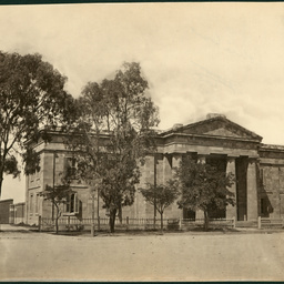
Angas Street
Angas Street, south side, showing Old Supreme Court building. This building with its pure Doric portico is constructed from sandstone. It was built between 1847 and 1850. Richard Lambeth was the architect and RG Bowen the builder. Until 1873 it was used as the Supreme Court, then until 1891 used for the Local and Insolvency Courts and then for the Police Force.

Jeffcott Street, North Adelaide
[General description] This large two storey stone building, complete with clock tower is situated on the corner of Jeffcott and Ward Streets. The photograph was probably taken around the time of the opening of the school in September 1882. A number of students and staff (and possibly student's families) are posing for the photographer on the footpath outside the walls of the school. [On back of photograph] 'A Sweet photograph (1882-86) of Whinham College, a prominent private school for 40 years / Previously the North Adelaide Grammar School it moved into this building in 1882 and closed in 1898 / It is now the Lutheran Immanuel Theological College'.

Adelaide Oval
[General description] Adelaide Oval looking north west towards North Adelaide. The view shows a horse drawn roller and three cricketers. The empty grandstand is in the background with a sign advertising "Members Tickets One Guinea to watch athletic sports on Adelaide Oval in April." A two tiered white picket fence surrounds the oval. [On back of photograph] Adelaide Oval, probably in the eighteen eighties. (Sweet Adelaide 528).

Botanic Gardens, Adelaide
[On front of photograph] 'Botanical Gardens, Adelaide, South Australia.' [General description] A view of water, probably the lake, surrounded by a mixture of native and exotic vegetation: willows, gum trees and grasses.

Fern House, Botanic Gardens
Victoria Regia House, Botanic Gardens. [Sweet] 33.

Botanic Gardens
Botanic Gardens showing the lake and surrounding willow trees. In the distance, through the trees, the lawns can be seen sloping up towards buildings outside the park.

Botanic Gardens
Entrance Gates, Botanic Gardens which were erected in 1876 or 1877. Provision for a public garden was made by Surveyor General Colonel William Light in his 1837 Plan for Adelaide. The site was recommended to the Government and George William Francis was appointed superintendent of the garden in 1855. A set of fine iron gates was purchased for the North Terrace entry. The gates have a double set of opening gates flanked by single opening gates on the side. Two gas lights sit on top of the ornate gate posts.

Botanic Gardens
The Rosery at the Botanic Gardens. Copy in Sweet Collection folder 3. A statue of a person riding a horse stands on a plinth in the centre of the rose garden surrounded by symmetrically placed rose beds.

Botanic Gardens
Botanic Gardens, Palm House. Palm House was designed by German architect Gustav Runge using hanging glass walls. This view of the Palm House shows its position on a rise with a flight of stairs flanked by two statues leading down to the path. A gentleman is standing at the top of the stairs.

Botanic Gardens
Avenue lined with Norfolk Island pine trees and palms in the Botanic Gardens. Two statues of dogs stand guard on either side of the avenue

Exhibition Building
[General description] Exhibition Building on North Terrace. Piles of rubble and stone suggest the building is still under construction. [On back of photograph] Exhibition Building, North Terrace. Probably 1887.

Exhibition Building
Exhibition Building, North Terrace.

Government House
[General description] Looking down on Government House and its garden from a building on North Terrace. The Union Jack is flying from a flag pole and the gatehouse guards the house and grounds. On King William Road the triple fronted building housing the Swimming Baths can be seen. The Rotunda stands in Elder Park and the steeples of North Adelaide can be seen above the trees. [On back of photograph] 'North Adelaide and Government House. Government Domain and City Road'.

North Terrace
[General description] North Terrace looking east towards the Adelaide Hills. The gardens of Government House, Library, Museum, Art Gallery and Exhibition Building can be seen along North Terrace. [On back of photograph] North Terrace, looking east. Probably in the eighteen nineties.

Rundle Road, Adelaide
Adelaide, viewed across the East Parklands, from Rundle Street, Kent Town, 1872-86. The Adelaide Hospital can be seen on the right of the photo, and the Scots Church spire is visible in the middle distance.

South Australian Institute
South Australian Institute Building, North Terrace photographed between 1872-83. The southern half of this building was built in 1860 and is an example of a Victorian building in the Renaissance style. It was designed by EA Hamilton. The northern portion was built in 1900.

South Australian Institute
South Australian Institute and the Public Library, North Terrace. The building was constructed in 1860 and is one of the oldest cultural buildings on North Terrace. It was built following lobbying to colonial government to establish a public library and museum

Torrens Lake
[General description] A man sketching the view across Torrens Lake with the Adelaide buildings in the background. The bridge in the photograph is possibly the Morphett Street Bridge and scaffolding on a new building can be seen towards the east on North Terrace in the vicinity of the railway yards. Henry [Hinton's] Free Store is visible on the southern bank of Torrens Lake. [On back of photograph] Torrens Lake.

Torrens Lake
[General description] Four man rowing team and its coxswain rowing on Torrens Lake. Photograph taken from the new weir, with the Montefiore Road Bridge, Railway station and city buildings in the distance. [On back of photograph] Torrens Lake 1881- 86. (Lake opened in 1881).