Find • Smith, D. Darian • Results 331 to 360 of 2,600


Kermode Street
[General description] School staff, students and their families are attending the opening of the New Wing (i.e. the first 20 rooms of what is now Newland Building).Marquees have been erected for the event. [On back of photograph] 'Reproduced in the Observer, April 24, 1926. Acre 712 / St. Mark's College, North Adelaide. The new wing / April 1926 / Frontage of east face:16.5 yards. Right side is 49.5 yards south of Kermode Street. East face is 126 yards west of John Street.'

O'Connell Street
O'Connell Street, North Adelaide, looking across Ward Street. A tram is travelling along the road. The building 2.5 inches from the left (single storey with Waratah sign) was demolished circa 1939. For building erected on site in 1941 see B 10901.

Piccadilly Cinema
Piccadilly Cinema, North Adelaide. (Initially believed to be the interior of the Star Theatre, Goodwood Road, Goodwood, now the Capri Cinema.)

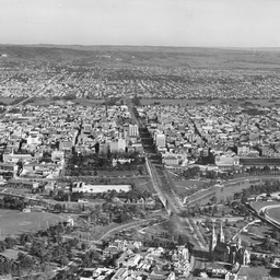
Adelaide
[General description] This aerial view focuses along King William Street and shows a portion of the southern section of Adelaide. In the foreground on the right is Government House and grounds and on the right is the Government Printing office and Parliament House. The new T&G building can be seen in the centre of the view, then the parklands, suburbs and distant hills. [On back of photograph] 'Reproduced in the 'Advertiser', April 11, 1928 / Aerial view of Adelaide / 1928'.

Adelaide
Aerial view of Adelaide between Victoria Square and Currie Street.

Adelaide
An aerial view of Adelaide taken in 1932 showing the buildings along North Terrace in the foreground and the city stretching back toward South Terrace in the background. Of interest are the gardens in Victoria Square, the trees in Whitmore Square and the gardens around Government House. The two tallest buildings appear on North Terrace and King William Street. The grid pattern and planning of Adelaide can be fully appreciated in this photograph.

Adelaide
Panoramic view of Adelaide.

Aerial view of Adelaide looking south east
Aerial view of Adelaide looking south east. The railway yards and Adelaide Railway Station are in the foreground. The city can be seen surrounded by the parkland on the eastern and southern sides. The Adelaide foothills can be seen in the distance.

Adelaide View
Aerial view of Adelaide.

Adelaide From Montefiore Hill
Adelaide looking south east from Montefiore Hill.
Adelaide View
Aerial view of Adelaide looking south from North Adelaide. The South Parklands provide an obvious barrier between the city and the southern suburbs.

Adelaide From Montefiore Hill
Aerial view of Adelaide looking south east from Montefiore Hill, 1939. Adelaide Oval and tennis courts are in the foreground, the taller buildings in the city loom next surrounded by the Adelaide Parklands and Race Course. The suburbs stretch out towards the Adelaide Hills in the distance.

Adelaide From Parklands
Aerial view of Adelaide from the Parklands.

Adelaide View
Aerial view of Adelaide.

Adelaide View
Aerial view of Adelaide.

Grenfell Street
Grenfell Street looking west. The Worando Building and A. W. Sandford buildings are on the left.

Aerial view of Adelaide
An aerial view of Adelaide looking northwest from above Tavistock Street. The Jubilee Exhibition Building opened in 1887, can be seen among the stately buildings along North Terrace. There is an empty building site opposite Scot's Church on the corner of North Terrace and Pulteney Street.

Pioneer Women's Memorial
Pioneer Women's Memorial Garden of Remembrance was officially opened and handed over to the City of Adelaide April19, 1941. The garden was designed by landscape designer Elsie Cornish and the statue created by Ola Cohn. A time recorder designed by the Government Astronomer George Dodwell is located on the left side of the statue.

Moore's Store Fire
Moore's store fire, Victoria Square.

Loch Torridon
Loch Torridon, ship at Port Adelaide.

Child prodigy Allison Nelson in concert
GENERAL: Allison Nelson, a South Australian child prodigy, playing the piano at a concert held in the Adelaide Town Hall in front of a packed audience.

Aerial view of Ingle Farm
INGLE FARM: Aerial view of Ingle Farm in 1972.

Supplies for the Cheer Up Hut
CHEER UP HUT: Four women volunteers and a soldier sorting food supplies at the Cheer Up hut; third from the left: Lorna Hughes; 4th from the left: Jean Taylor.

The Adelaide Chemical and Fertilizer Company
PORT ADELAIDE: The Adelaide Chemical and Fertilizer Company Works: aerial view.

Adelaide Chemical & Fertilizer Company Works
PORT ADELAIDE: Interior view showing the bagging process at the Adelaide Chemical & Fertilizer Company Works showing an eight head rotary bagger and constant height rotating hydraulic bagging platform.

Seppeltsfield wine cellar
SEPPELTSFIELD: Wine Cellar.

Seppeltsfield underground wine cellar
SEPPELTSFIELD: Underground wine cellar in a corridor called Lord Hopetoun Drive after an early Governor General.

Men harvesting at Paradise
PARADISE: Men harvesting celery at Paradise.

Celery waiting to be shipped from Port Adelaide
PORT ADELAIDE: Lorry loads of celery on a wharf at Port Adelaide waiting for shipment.

Celery being loaded on to a ship at Port Adelaide
PORT ADELAIDE: Celery being loaded on to a ship at Port Adelaide.