Find • Smith, D. Darian • Results 91 to 120 of 2,435


Bowling club, Hindmarsh
Ceremonial opening of the Hindmarsh Bowling Club.

Bowling Club, Hindmarsh
A scene at the opening of the Hindmarsh Bowling Club.

Bowling Club, Hindmarsh
Bowling first ball at the opening of the Bowling Club.

Bowling Club, Hindmarsh
General scene on opening day at the Bowling Club.

Bowling Club, Hindmarsh
Group view on the opening day of Hindmarsh Bowling Club.

Kadina
Aerial view of part of Wallaroo Mines (looking east). The hill in centre is the residue or tailings dump at Devon Concentrating Plant. Behind is Federal Cricket Ground, also called "Lords". Buildings in foreground are the ruins of Devon Concentrating Plant, Wallaroo Mines.

Malt display, Kent Town
Barrett Bros., Maltsters, display.

Office workers, Keswick
Office workers working with comptometers at Richards Motor Body Builders, Keswick.

Residence, Koonunga
Property of C. M. Bagot, taken from a sketch.

Aerial view of Goolwa
[General description] Aerial view of the Township of Goolwa in 1936, showing town buildings and network of roads. Various small craft can be seen on the River Murray in the foreground.

Aerial view of Mannum
Aerial view of Mannum.

Mount Bold Reservoir
Aerial view of Mount Bold Reservoir.

Mount Lofty lookout
Aerial view of Mount Lofty lookout.

Aerial view of Murray Bridge
Aerial view of Murray Bridge.

Murray Mouth
Aerial view of the Murray Mouth.

Boiler House, Osborne
Ash tips in front of Boiler House at Osborne.

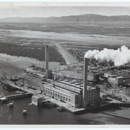
Osborne Power Station
Aerial view of the Power Station.

Cheer-Up Hut, Adelaide, showing Peterborough wing
The Cheer Up Hut, neat the Adelaide Railway Station.

Nile Street, Port Adelaide
Premises in Nile Street Port Adelaide, south side, nearly opposite the Sailor's Rest in 1928. Formerly used for public stores at Old Port . These were demolished early in 1929. Under the corregated iron is one of the two half-round structures erected at the Old Port in the early days for housing public stores. It had a smooth (not corregated) iron roof, supported by a framework or iron. these old stores can be seen in Light's view of the Old Port (B 508) By 1844 they had been moved to the New Port (B 2220) The photograph depicts a man and a boy standing at the raised doorway to the business premises of Fred. A Elix Forage Merchant. A man in a car is parked in the street in front of the building.

Aerial view of Port Adelaide
Aerial view of wharves at Port Adelaide.

Aerial view of Port Adelaide
Aerial view of wharves at Port Adelaide.

Aerial view of Port Adelaide
Aerial view of wharves at Port Adelaide.
Thomas Playford Power Station
The Thomas Playford Power Station, Port Augusta.

Port Pirie
Aerial view of Port Pirie in 1929.

Port Pirie
Aerial view of Port Pirie in 1929 showing two ships moored at the wharf.

Pantoon crane, Port Adelaide
Pantoon crane at the rear of Old Jervois Bridge.

Aerial view of Port Augusta
Aerial view. Port Augusta looking south over the old Great Western Bridge.

Bowman's Depot
An aerial view of Bowman's Depot.

Patio at "Strathspey"
Eastern wall of patio at "Strathspey", Springfield.

"Stirling Hotel"
"Stirling Hotel" in Stirling West was originally known as the Halfway Inn which was a reference to its position between Adelaide and Mount Barker